|
search place name
|
||
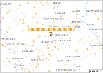
Douar Ouled Sidi Lazreg (Relizane, Algeria)Douar Ouled Sidi Lazreg is a town in the Relizane region of Algeria. An overview map of the region around Douar Ouled Sidi Lazreg is displayed below.
regional and 3d topo map of Douar Ouled Sidi Lazreg, Algeria ::
Douar Ouled Sidi Lazreg airports ::
The nearest airport is MUW - Ghriss, located 70.8 km south west of Douar Ouled Sidi Lazreg.
Other airports nearby include TID - Tiaret Bou Chekif (72.6 km south east), QAS - Ech-cheliff Ech Cheliff (84.6 km north east), TAF - Oran Tafaraoui (115.7 km west), ORN - Oran Es Senia (123.3 km west), Nearby towns ::
Douar Ouled Djelloul (0.9km west) //
Douar Ouled Ameur (2.0km west) //
Douar Lemaâziz (2.6km north) //
El Moaziz (2.6km north east) //
Bou Guetaïa (2.7km south east) //
Douar Bousseki (3.2km south) //
Oulad Smaïn (3.4km south) //
Douar ez Zhaïria (3.2km north west) //
Oulad Sidi Ali (3.0km east) //
Douar Ouled Ben Ali (3.7km south) //
Douar el Guradib (3.4km north west) //
Douar Oulad Ben Ali (3.9km south) //
Douar Laâbaydia (4.0km north) //
Douar Oulad Nouasseur (3.5km west) //
Douar Ben Sidi Ahmed (4.3km south) //
Oulad Sidi el Arbi (4.3km south east) //
Douar Ben Doubia (4.1km west) //
Douar Mohamedi (5.0km south) //
Douar Oulad Ben Sidi Mohammed (5.0km south east) //
Douar Ouled Ben Yahia Mustapha (4.4km west) //
Douar Sidi Abdelaziz (5.5km north) //
Douar Mohammed Bel Djilali (5.4km north west) //
Douar Reguaïguia (6.0km south west) //
Mohammed Ben Azzouz (5.2km east) //
Zaïlal (5.3km west) //
Douar Sghaïria (6.5km south) //
Douar Ouled Sidi Bekheda (6.1km south west) //
Eddarssa (5.6km west) //
Cheikh Menouar (5.6km east) //
[all distances 'as the bird flies' and approximate]  Places with similar names to Douar Ouled Sidi Lazreg, Algeria ::
// Douar Oulad Sidi el Azreg (DZ)
Disclaimer :: Information on this page comes without warranty of any kind |
||
|
Where is Douar Ouled Sidi Lazreg? Elevation and coordinates ::
Latitude (lat): 35°37'16"N Longitude (lon): 0°44'25"W
Elevation (approx.): 394m (map arrows pan, magnifying glasses zoom) |
||
|
Visiting Douar Ouled Sidi Lazreg? Hotel/Accommodation ::
Book a hotel in Douar Ouled Sidi Lazreg Travel Guide ::
Buy a travel guide for Algeria rental cars ::
car rental offers GPS waypoint ::
download a GPX waypoint (PoI) of Douar Ouled Sidi Lazreg for your GPS receiver
|
||