|
search place name
|
||
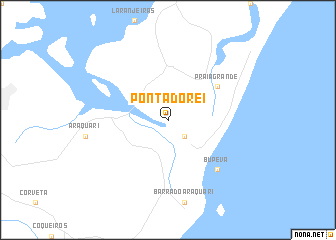
Ponta do Rei (Santa Catarina, Brazil)Ponta do Rei is a town in the Santa Catarina region of Brazil. An overview map of the region around Ponta do Rei is displayed below.
regional and 3d topo map of Ponta do Rei, Brazil ::
Ponta do Rei airports ::
The nearest airport is JOI - Joinville Lauro Carneiro De Loyola, located 22.7 km north west of Ponta do Rei.
Other airports nearby include NVT - Navegantes Ministro Victor Konder Intl (56.9 km south), CWB - Curitiba Afonso Pena (107.6 km north west), BFH - Curitiba Bacacheri (122.3 km north west), FLN - Florianopolis Hercilio Luz (144.7 km south), Nearby towns ::
Bupeva (2.5km south east) //
Praia Grande (6.2km north east) //
Bupeva (7.5km south east) //
[all distances 'as the bird flies' and approximate]  Places with similar names to Ponta do Rei, Brazil ::
// Ponta da Areia (BR)
// Punta Tierra (PA)
// Punta Toro (PA)
// Ponte Taro (IT)
// Puente Duero (ES)
// Puentedura (ES)
// Puente Tierra (CO)
// Puentetierra (CO)
// Puentetierra (CO)
// Pāndātarai (IN)
Disclaimer :: Information on this page comes without warranty of any kind |
||
|
Where is Ponta do Rei? Elevation and coordinates ::
Latitude (lat): 26°22'0"S Longitude (lon): 48°38'0"W
Elevation (approx.): 5m (map arrows pan, magnifying glasses zoom) |
||
|
Visiting Ponta do Rei? Hotel/Accommodation ::
Book a hotel in Ponta do Rei Travel Guide ::
Buy a travel guide for Brazil rental cars ::
car rental offers GPS waypoint ::
download a GPX waypoint (PoI) of Ponta do Rei for your GPS receiver
|
||