|
search place name
|
||
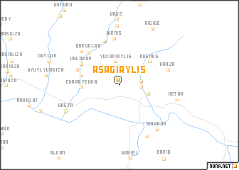
Aşağı Əylis (Naxçıvan, Azerbaijan)Aşağı Əylis is a town in the Naxçıvan region of Azerbaijan. An overview map of the region around Aşağı Əylis is displayed below.
regional and 3d topo map of Aşağı Əylis, Azerbaijan ::
Aşağı Əylis airports ::
The nearest airport is TBZ - Tabriz Intl, located 89.9 km south of Aşağı Əylis.
Nearby towns ::
Ashagy Andamich (2.6km east) //
Yuxarı Əndǝli (2.8km east) //
Yuxarı Əylis (3.7km north) //
Ordubad (3.8km east) //
Chapayevka (4.6km west) //
Agry (4.6km west) //
Nüsnüs (5.3km north east) //
Diza (4.8km west) //
Valavar (5.7km north west) //
Qoruglar (6.3km north west) //
Vǝnǝnd (5.7km north west) //
Danaqırt (7.1km north) //
Dırnıs (7.4km north) //
Disar (7.0km north west) //
Kǝnzǝ (6.4km north east) //
Sīah Rūd (8.3km south east) //
Īrī-ye Soflá (8.7km south) //
Dǝstǝ (7.7km south west) //
[all distances 'as the bird flies' and approximate] 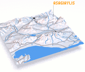 Places with similar names to Aşağı Əylis, Azerbaijan :: Disclaimer :: Information on this page comes without warranty of any kind |
||
|
Where is Aşağı Əylis? Elevation and coordinates ::
Latitude (lat): 38°55'11"N Longitude (lon): 45°59'11"E
Elevation (approx.): 848m (map arrows pan, magnifying glasses zoom) |
||
|
Visiting Aşağı Əylis? Hotel/Accommodation ::
Book a hotel in Aşağı Əylis Travel Guide ::
Buy a travel guide for Azerbaijan rental cars ::
car rental offers GPS waypoint ::
download a GPX waypoint (PoI) of Aşağı Əylis for your GPS receiver
|
||