|
search place name
|
||
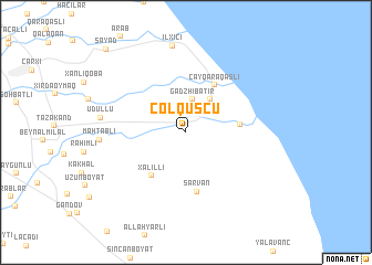
Çöl Quşçu (Dǝvǝçi, Azerbaijan)Çöl Quşçu is a town in the Dǝvǝçi region of Azerbaijan. An overview map of the region around Çöl Quşçu is displayed below.
regional and 3d topo map of Çöl Quşçu, Azerbaijan ::
Çöl Quşçu airports ::
The nearest airport is BAK - Baku Heydar Aliyev, located 130.1 km south east of Çöl Quşçu.
Other airports nearby include MCX - Makhachkala Uytash (199.2 km north west), Nearby towns ::
(( Gadzhibatir )) (3.4km north) //
(( Mamedoba )) (3.8km north east) //
Haçı Qaraqaşlı (4.2km east) //
Xǝlilli (5.1km south west) //
Çay Qaraqaşlı (5.2km north east) //
Sarvan (6.1km south) //
Udullu (6.6km west) //
Mahtablı (6.6km west) //
İlxıçı (8.8km north) //
Sayad (10.3km north west) //
[all distances 'as the bird flies' and approximate]  Places with similar names to Çöl Quşçu, Azerbaijan ::
// Calexico (US)
// Kałkowskie (PL)
// Kiełczówka (PL)
// Kliczków (PL)
// Kliczkowy (PL)
// Kołaczki (PL)
// Kołaczków (PL)
// Galgauska (LV)
// Kulakskiy (RU)
// Kalkaska (US)
Disclaimer :: Information on this page comes without warranty of any kind |
||
|
Where is Çöl Quşçu? Elevation and coordinates ::
Latitude (lat): 41°20'12"N Longitude (lon): 49°0'39"E
Elevation (approx.): -17m (map arrows pan, magnifying glasses zoom) |
||
|
Visiting Çöl Quşçu? Hotel/Accommodation ::
Book a hotel in Çöl Quşçu Travel Guide ::
Buy a travel guide for Azerbaijan rental cars ::
car rental offers GPS waypoint ::
download a GPX waypoint (PoI) of Çöl Quşçu for your GPS receiver
|
||