|
search place name
|
||
Hacıağabǝyli (Göyçay, Azerbaijan)Hacıağabǝyli is a town in the Göyçay region of Azerbaijan. An overview map of the region around Hacıağabǝyli is displayed below.
regional and 3d topo map of Hacıağabǝyli, Azerbaijan ::

Nearby towns ::
Yeniarx (1.7km south east) //
Ərǝbşahverdi (2.3km north) //
Müskürlü (2.9km south) //
Mallı (2.8km north east) //
Qǝbǝlǝ Müskürlü (4.0km south) //
Xalidli (3.6km east) //
Çǝrǝkǝ (4.0km south east) //
Cǝyirli (4.6km south east) //
Çǝrǝcǝ (5.0km east) //
Birinci Aral (5.3km north west) //
Ucar (7.2km south) //
Qarabağlar (6.9km north east) //
İkinci Aral (5.9km west) //
Rǝstǝcǝ (7.0km south east) //
Ulaşlı Şıxlı (6.2km east) //
Mirzǝhüseynli (8.2km north) //
Birinci Ərǝbcǝbirli (8.0km north east) //
Ərǝbşahverdi (8.0km north east) //
Xosrov (7.6km north west) //
İkinci Ərǝbcǝbirli (7.9km north east) //
Şǝmsabad (8.0km north west) //
Çiyni (8.1km south west) //
[all distances 'as the bird flies' and approximate] 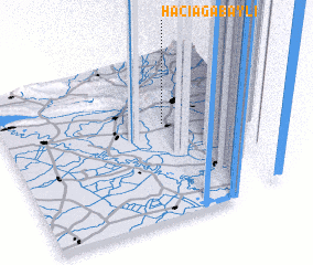 Places with similar names to Hacıağabǝyli, Azerbaijan :: Disclaimer :: Information on this page comes without warranty of any kind |
||
|
Where is Hacıağabǝyli? Elevation and coordinates ::
Latitude (lat): 40°35'0"N Longitude (lon): 47°39'0"E
Elevation (approx.): 28m (map arrows pan, magnifying glasses zoom) |
||
|
Visiting Hacıağabǝyli? Hotel/Accommodation ::
Book a hotel in Hacıağabǝyli Travel Guide ::
Buy a travel guide for Azerbaijan rental cars ::
car rental offers GPS waypoint ::
download a GPX waypoint (PoI) of Hacıağabǝyli for your GPS receiver
|
||