|
search place name
|
||
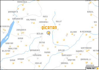
Qıçatan (İsmayıllı, Azerbaijan)Qıçatan is a town in the İsmayıllı region of Azerbaijan. An overview map of the region around Qıçatan is displayed below.
regional and 3d topo map of Qıçatan, Azerbaijan ::
Qıçatan airports ::
The nearest airport is BAK - Baku Heydar Aliyev, located 140.4 km east of Qıçatan.
Nearby towns ::
Kürdüvan (3.1km north) //
Zeyvǝ (3.0km north west) //
Bizlan (2.6km west) //
Kǝlǝzeyvǝ (3.1km north east) //
Pirqaraçuxa (3.5km south east) //
Basqal (3.7km north west) //
Xankǝndi (4.1km north west) //
Nüydü (4.4km south west) //
Sanqalan (4.8km south) //
Xasıdǝrǝ (5.2km south) //
Sulut (5.0km north east) //
Suraxanı (4.5km south east) //
Mücü (6.0km north) //
Kalva (4.8km east) //
Xatman (5.0km east) //
Tağlabiyan (6.5km north west) //
Nuran (7.8km south) //
Kǝlfǝrǝc (6.9km north west) //
Hacıman (6.4km east) //
Qırlar (7.9km south east) //
Qendaxan (8.2km south west) //
Pirǝbülqasım (7.8km south west) //
Yenikǝnd (9.5km south) //
Gürcüvǝn (10.2km south east) //
Zǝrnava (10.3km north west) //
[all distances 'as the bird flies' and approximate]  Places with similar names to Qıçatan, Azerbaijan ::
Disclaimer :: Information on this page comes without warranty of any kind |
||
|
Where is Qıçatan? Elevation and coordinates ::
Latitude (lat): 40°43'48"N Longitude (lon): 48°25'25"E
Elevation (approx.): 834m (map arrows pan, magnifying glasses zoom) |
||
|
Visiting Qıçatan? Hotel/Accommodation ::
Book a hotel in Qıçatan Travel Guide ::
Buy a travel guide for Azerbaijan rental cars ::
car rental offers GPS waypoint ::
download a GPX waypoint (PoI) of Qıçatan for your GPS receiver
|
||