|
search place name
|
||
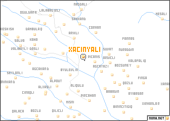
Xaçınyalı (Laçın, Azerbaijan)Xaçınyalı is a town in the Laçın region of Azerbaijan. An overview map of the region around Xaçınyalı is displayed below.
regional and 3d topo map of Xaçınyalı, Azerbaijan ::
Xaçınyalı airports ::
The nearest airport is TBZ - Tabriz Intl, located 186.3 km south of Xaçınyalı.
Nearby towns ::
Piçǝnis (1.7km east) //
Kürdhacı (2.5km north west) //
Ağcayazı (3.7km south east) //
Byulevlik (4.0km south west) //
Mundzhuglu (4.0km north west) //
Suvat (4.3km east) //
Ardıclı (4.3km east) //
Ərikli (5.3km north) //
Çorman (6.4km north) //
Vaqazin (5.6km south east) //
Əliqulu (6.8km south) //
Dǝrǝkǝnd (7.0km south east) //
Ərdǝşǝvi (7.0km south east) //
Şamkǝnd (8.1km north) //
Alpout (7.4km south west) //
Qaraçanlı (8.0km south) //
Qoşasu (7.0km south west) //
Bozgüney (6.9km east) //
Pircahan (8.9km south) //
Korcabulaq (8.1km north west) //
Qarabǝyli (8.7km north west) //
Hǝtǝmlǝr (7.3km west) //
Tǝzǝkǝnd (7.9km south east) //
Babadin (9.4km south east) //
Alxaslı (9.6km south west) //
Arduşlu (10.0km south west) //
[all distances 'as the bird flies' and approximate]  Places with similar names to Xaçınyalı, Azerbaijan :: Disclaimer :: Information on this page comes without warranty of any kind |
||
|
Where is Xaçınyalı? Elevation and coordinates ::
Latitude (lat): 39°48'20"N Longitude (lon): 46°25'37"E
Elevation (approx.): 1400m (map arrows pan, magnifying glasses zoom) |
||
|
Visiting Xaçınyalı? Hotel/Accommodation ::
Book a hotel in Xaçınyalı Travel Guide ::
Buy a travel guide for Azerbaijan rental cars ::
car rental offers GPS waypoint ::
download a GPX waypoint (PoI) of Xaçınyalı for your GPS receiver
|
||