|
search place name
|
||
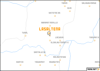
La Salteña (Tarija, Bolivia)La Salteña is a town in the Tarija region of Bolivia. An overview map of the region around La Salteña is displayed below.
regional and 3d topo map of La Salteña, Bolivia ::
La Salteña airports ::
The nearest airport is TJA - Tarija Capitan Oriel Lea Plaza, located 66.4 km south west of La Salteña.
Other airports nearby include BYC - Yacuiba (94.1 km south east), BJO - Bermejo (169.5 km south), ORA - Oran (211.5 km south), POI - Potosi Capitan Nicolas Rojas (250.4 km north west), Nearby towns ::
La Laguna (0.0km north) //
San Simón (1.9km south) //
Potrerillo (1.9km north) //
Abra Potrerillo (3.7km north) //
La Cueva (3.9km south east) //
El Saladito Norte (5.1km south east) //
El Saladito (7.6km south) //
Siete Tacos (7.6km north) //
Santa Lucía (8.2km south west) //
[all distances 'as the bird flies' and approximate] 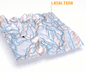 Places with similar names to La Salteña, Bolivia ::
// Los Saldaña (PA)
// La Cellettina (IT)
// La Sultana (CU)
// Lisletown (US)
// La Saltana (CO)
// Lasuleten (TP)
// La Sultana (MX)
// La Sultana (VE)
// LʼIsle-de-Noé (FR)
// Laisaliden (SE)
Disclaimer :: Information on this page comes without warranty of any kind |
||
|
Where is La Salteña? Elevation and coordinates ::
Latitude (lat): 21°15'0"S Longitude (lon): 64°9'0"W
Elevation (approx.): 1141m (map arrows pan, magnifying glasses zoom) |
||
|
Visiting La Salteña? Hotel/Accommodation ::
Book a hotel in La Salteña Travel Guide ::
Buy a travel guide for Bolivia rental cars ::
car rental offers GPS waypoint ::
download a GPX waypoint (PoI) of La Salteña for your GPS receiver
|
||