|
search place name
|
||
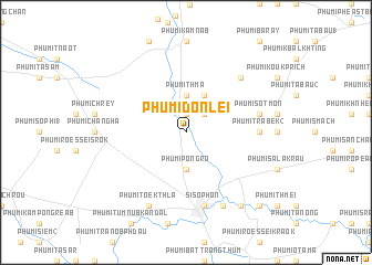
Phumĭ Don Lei (Bătdâmbâng, Cambodia)Phumĭ Don Lei is a town in the Bătdâmbâng region of Cambodia. An overview map of the region around Phumĭ Don Lei is displayed below.
regional and 3d topo map of Phumĭ Don Lei, Cambodia ::
Phumĭ Don Lei airports ::
The nearest airport is REP - Siem-reap Siem Reap, located 95.3 km east of Phumĭ Don Lei.
Other airports nearby include NAK - Nakhon Ratchasima Khorat (171.4 km north west), UTP - Rayong U Taphao Intl (238.2 km south west), Nearby towns ::
Phumĭ Kbal Spéan (1.9km north) //
Phumĭ Mkăk (1.9km north) //
Phumĭ Chhuk (2.6km north east) //
Phumĭ Thmâ (3.7km north) //
Phumĭ Pôngrô (3.7km south) //
Phumĭ Liĕb (4.1km north east) //
Phumĭ Trâbêk (2) (7.2km east) //
Phumĭ Ta Méas (7.2km east) //
Phumĭ Sot Môn (7.4km east) //
Sisŏphŏn (7.6km south) //
Phumĭ Preăh Pônléa (1) (7.6km south) //
Phumĭ Kâmpóng Svay (7.6km south) //
Phumĭ Koŭk Phchœ̆k (7.8km north east) //
Phumĭ Ta Tŏng (8.2km south east) //
Phumĭ Tœ̆k Thla (8.2km south west) //
Phumĭ Kaôh Pông Sâtv (9.2km south east) //
Phumĭ Kântuŏt (9.2km south east) //
Phumĭ Ta Sŏk (10.3km south east) //
Phumĭ Kâmpring (10.3km south east) //
[all distances 'as the bird flies' and approximate]  Places with similar names to Phumĭ Don Lei, Cambodia ::
// Phumĭ Don L'â (KH)
// Phumĭ Don Lôy (KH)
// Phumĭ Ta Năl (KH)
// Phumĭ Ta Nél (KH)
// Phumĭ Teun Leu (KH)
// Phumĭ Tônlé (KH)
// Phumĭ Tônléa (KH)
Disclaimer :: Information on this page comes without warranty of any kind |
||
|
Where is Phumĭ Don Lei? Elevation and coordinates ::
Latitude (lat): 13°39'0"N Longitude (lon): 102°58'0"E
Elevation (approx.): 12m (map arrows pan, magnifying glasses zoom) |
||
|
Visiting Phumĭ Don Lei? Hotel/Accommodation ::
Book a hotel in Phumĭ Don Lei Travel Guide ::
Buy a travel guide for Cambodia rental cars ::
car rental offers GPS waypoint ::
download a GPX waypoint (PoI) of Phumĭ Don Lei for your GPS receiver
|
||