|
search place name
|
||
Phumĭ Kâmpóng Reăng (Kâmpóng Cham, Cambodia)Phumĭ Kâmpóng Reăng is a town in the Kâmpóng Cham region of Cambodia. An overview map of the region around Phumĭ Kâmpóng Reăng is displayed below.
regional and 3d topo map of Phumĭ Kâmpóng Reăng, Cambodia ::

Phumĭ Kâmpóng Reăng airports ::
The nearest airport is PNH - Phnom-penh Phnom Penh Intl, located 140.5 km south west of Phumĭ Kâmpóng Reăng.
Other airports nearby include SGN - Ho Chi Minh City Tansonnhat Intl (170.9 km south east), Nearby towns ::
Phumĭ Chitrŭn (4.1km south east) //
Phumĭ Kâmpông Srê (5.2km north east) //
Phumĭ Véal Toch (5.2km south west) //
Chhlong (5.8km north) //
Phumĭ Pôngrô (5.8km north) //
Phumĭ Hănchey Leu (5.8km north) //
Phumĭ Bânghaeur Khlêng (6.6km south east) //
Phumĭ Bœ̆ng Kiĕb (7.2km east) //
Phumĭ Kbal Kaôh Tasŭy (7.6km north) //
Phumĭ Dâng Kdaông (7.8km north west) //
Phumĭ Dei Thmei (7.8km north east) //
Phumĭ Prey Koŭ (8.1km north east) //
Phumĭ Kbal Rôméas (9.2km south east) //
Phumĭ Ângchar (9.2km north east) //
Phumĭ Tnaôt (9.1km north west) //
Phumĭ Lvéa Thum (10.4km north east) //
[all distances 'as the bird flies' and approximate] 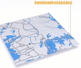 Places with similar names to Phumĭ Kâmpóng Reăng, Cambodia ::
// Phumĭ Kâmpóng Reăng (KH)
Disclaimer :: Information on this page comes without warranty of any kind |
||
|
Where is Phumĭ Kâmpóng Reăng? Elevation and coordinates ::
Latitude (lat): 12°12'0"N Longitude (lon): 105°57'0"E
Elevation (approx.): 19m (map arrows pan, magnifying glasses zoom) |
||
|
Visiting Phumĭ Kâmpóng Reăng? Hotel/Accommodation ::
Book a hotel in Phumĭ Kâmpóng Reăng Travel Guide ::
Buy a travel guide for Cambodia rental cars ::
car rental offers GPS waypoint ::
download a GPX waypoint (PoI) of Phumĭ Kâmpóng Reăng for your GPS receiver
|
||