|
search place name
|
||
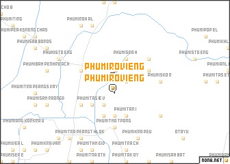
Phumĭ Rôviĕng (Siĕm Réab, Cambodia)Phumĭ Rôviĕng is a town in the Siĕm Réab region of Cambodia. An overview map of the region around Phumĭ Rôviĕng is displayed below.
regional and 3d topo map of Phumĭ Rôviĕng, Cambodia ::
Phumĭ Rôviĕng airports ::
The nearest airport is REP - Siem-reap Siem Reap, located 23.4 km south west of Phumĭ Rôviĕng.
Other airports nearby include PNH - Phnom-penh Phnom Penh Intl (236.5 km south east), NAK - Nakhon Ratchasima Khorat (260.0 km north west), PKZ - Pakse (262.4 km north east), Nearby towns ::
Khvav (1.9km north) //
Phumĭ Rôviĕng (1.9km south) //
Phumĭ Tbêng (1.8km east) //
Phumĭ Srăh (4.1km north east) //
Phumĭ Thlôk (4.1km south west) //
Phumĭ Ta Siĕv (5.2km south west) //
Phumĭ Rŭn (5.6km south) //
Phumĭ Khna (5.7km west) //
Phumĭ Rôka Péam (2) (5.7km east) //
Phumĭ Tani (5.8km south) //
Phumĭ Rŭn (5.8km south) //
Phumĭ Rôka Péam (1) (6.6km north east) //
Phumĭ Ta Kaôh (6.6km south west) //
Phumĭ Skón (7.2km east) //
Phumĭ Tmat Pông (7.4km south) //
Phumĭ Ta Êk (7.4km south) //
Phumĭ Sna Sângkréam (9.1km south east) //
[all distances 'as the bird flies' and approximate]  Places with similar names to Phumĭ Rôviĕng, Cambodia ::
// Phumĭ Raivóng (KH)
// Phumĭ Rôviĕng (KH)
// Phumĭ Rôviĕng (KH)
// Phumĭ Rôviĕng (KH)
// Phumĭ Rôviĕng (KH)
// Phumĭ Rôviĕng (KH)
// Phumĭ Rôviĕng (KH)
// Phumĭ Rôviĕng (KH)
// Phumĭ Rôviĕng (KH)
Disclaimer :: Information on this page comes without warranty of any kind |
||
|
Where is Phumĭ Rôviĕng? Elevation and coordinates ::
Latitude (lat): 13°31'0"N Longitude (lon): 104°0'0"E
Elevation (approx.): 45m (map arrows pan, magnifying glasses zoom) |
||
|
Visiting Phumĭ Rôviĕng? Hotel/Accommodation ::
Book a hotel in Phumĭ Rôviĕng Travel Guide ::
Buy a travel guide for Cambodia rental cars ::
car rental offers GPS waypoint ::
download a GPX waypoint (PoI) of Phumĭ Rôviĕng for your GPS receiver
|
||