|
search place name
|
||
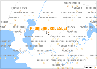
Phumĭ Snaôr Roes Dei (Kâmpóng Thum, Cambodia)Phumĭ Snaôr Roes Dei is a town in the Kâmpóng Thum region of Cambodia. An overview map of the region around Phumĭ Snaôr Roes Dei is displayed below.
regional and 3d topo map of Phumĭ Snaôr Roes Dei, Cambodia ::
Phumĭ Snaôr Roes Dei airports ::
The nearest airport is PNH - Phnom-penh Phnom Penh Intl, located 135.0 km south of Phumĭ Snaôr Roes Dei.
Other airports nearby include REP - Siem-reap Siem Reap (136.2 km north west), SGN - Ho Chi Minh City Tansonnhat Intl (289.1 km south east), Nearby towns ::
Phumĭ Khnar (2.6km north west) //
Phumĭ Trâpeăng Rœssei (2.6km north west) //
Phumĭ Véal Vôngs (2.6km south east) //
Phumĭ Prasat (4.1km north west) //
Phumĭ Thnál Bêk (4.1km south east) //
Phumĭ Koŭk Ngun (5.2km south west) //
Phumĭ Krâchăb (5.2km south east) //
Phumĭ O Kântreăng (5.6km north) //
Phumĭ Prey Préal (5.7km west) //
Phumĭ Krâsăng (5.7km west) //
Phumĭ Sânláb Pôpôk (5.7km west) //
Phumĭ Achary Leăk (5.8km south) //
Phumĭ Poŭ Băk (5.8km south) //
Phumĭ Skón (7.4km north) //
Phumĭ Prey Prâs (1) (7.5km west) //
Phumĭ Voăll Yéav (7.5km east) //
Phumĭ Kdei Dong (7.6km south) //
Phumĭ Prêk Sbov (7.6km south) //
Kâmpóng Thum (7.6km south) //
Phumĭ Prén (7.8km south east) //
Phumĭ O Ândêng (7.8km north west) //
Phumĭ Snêng Krâbei (7.8km south west) //
Phumĭ Prey Kŭy (7.8km south east) //
Phumĭ Chbar Sla (7.8km south east) //
Phumĭ O Kânthôr (8.2km south west) //
Phumĭ Séng (9.2km north west) //
Phumĭ Svay Khloŭk (9.1km south east) //
Phumĭ Phlông (10.4km north west) //
Phumĭ Péam Trêng (10.4km south west) //
[all distances 'as the bird flies' and approximate]  Places with similar names to Phumĭ Snaôr Roes Dei, Cambodia :: Disclaimer :: Information on this page comes without warranty of any kind |
||
|
Where is Phumĭ Snaôr Roes Dei? Elevation and coordinates ::
Latitude (lat): 12°46'0"N Longitude (lon): 104°53'0"E
Elevation (approx.): 17m (map arrows pan, magnifying glasses zoom) |
||
|
Visiting Phumĭ Snaôr Roes Dei? Hotel/Accommodation ::
Book a hotel in Phumĭ Snaôr Roes Dei Travel Guide ::
Buy a travel guide for Cambodia rental cars ::
car rental offers GPS waypoint ::
download a GPX waypoint (PoI) of Phumĭ Snaôr Roes Dei for your GPS receiver
|
||