|
search place name
|
||
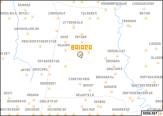
Baiāra (Barisāl, Bangladesh)Baiāra is a town in the Barisāl region of Bangladesh. An overview map of the region around Baiāra is displayed below.
regional and 3d topo map of Baiāra, Bangladesh ::
Baiāra airports ::
The nearest airport is IXA - Agartala, located 85.5 km north of Baiāra.
Other airports nearby include DAC - Dhaka Zia Intl (113.7 km north west), CGP - Chittagong Shah Amanat Intl (115.8 km south east), IXH - Kailashahar (156.4 km north east), AJL - Aizwal Aizawl (179.6 km north east), Nearby towns ::
Jodda (2.0km north east) //
Patwār (3.7km north) //
Pujkara (3.9km north west) //
Ghorāmaīdān (3.9km south west) //
Ādra (5.0km north west) //
Dhālua (5.1km east) //
Nāogoda (5.6km north) //
Chhatarpaia (6.0km south) //
Uttar Hawla (7.3km north) //
Metua (7.6km north) //
Nātherpetua (7.1km west) //
Mannāra (7.1km east) //
Bīrkot (7.6km south) //
Bakshganj (7.6km south east) //
Nangalkot (7.6km east) //
Kānchi (7.8km south west) //
Dakshin Hawla (8.2km north west) //
Daulkhār (8.0km south east) //
Sonāimuri (9.9km south west) //
Dumuria (10.1km south east) //
[all distances 'as the bird flies' and approximate] 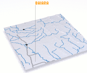 Places with similar names to Baiāra, Bangladesh ::
Disclaimer :: Information on this page comes without warranty of any kind |
||
|
Where is Baiāra? Elevation and coordinates ::
Latitude (lat): 23°7'0"N Longitude (lon): 91°11'0"E
Elevation (approx.): 10m (map arrows pan, magnifying glasses zoom) |
||
|
Visiting Baiāra? Hotel/Accommodation ::
Book a hotel in Baiāra Travel Guide ::
Buy a travel guide for Bangladesh rental cars ::
car rental offers GPS waypoint ::
download a GPX waypoint (PoI) of Baiāra for your GPS receiver
|
||