|
search place name
|
||
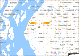
Sādullāhpur (Barisāl, Bangladesh)Sādullāhpur is a town in the Barisāl region of Bangladesh. An overview map of the region around Sādullāhpur is displayed below.
regional and 3d topo map of Sādullāhpur, Bangladesh ::
Sādullāhpur airports ::
The nearest airport is DAC - Dhaka Zia Intl, located 82.2 km north of Sādullāhpur.
Other airports nearby include IXA - Agartala (104.0 km north east), JSR - Jessore (150.9 km west), CGP - Chittagong Shah Amanat Intl (155.8 km south east), IXH - Kailashahar (191.2 km north east), Nearby towns ::
Hānār Char (0.2km north east) //
Bāzeāpti (1.7km west) //
Ichāli (1.9km north) //
Gāzīpur Manipur (2.5km south west) //
Lāmchari (2.5km south east) //
Induli (2.5km north west) //
Gorāpia (2.5km north west) //
Gobindia (2.5km north east) //
Gāzipur Kutubpur (3.4km west) //
Manipur (3.4km west) //
Bākharpur (3.4km east) //
Gunāndi Chāndpur (3.7km north) //
Mirzāpur (3.7km north) //
Mulāmbāri (3.9km south west) //
South Ālgi (4.1km south east) //
Char Solādi (4.1km south east) //
Mahazampur (4.1km south east) //
Nayāni Lakshmīpur (3.9km south east) //
Kāunia (4.1km north west) //
Sāpleja (4.1km north west) //
South Bālia (3.9km north east) //
Kamalāpur (5.0km south east) //
North Ālgi (5.0km south east) //
Chhota Lakshmīpur (5.0km south east) //
Narasinhapur (5.0km north west) //
Ibrāhimpur (5.0km north west) //
Chālitātali (5.3km north west) //
Bhingulia (5.1km east) //
Khānepūra (5.1km west) //
[all distances 'as the bird flies' and approximate]  Places with similar names to Sādullāhpur, Bangladesh ::
// Sadalpur (BD)
// Sadullāhpur (BD)
// Sadullapur (BD)
// Sādullāpur (BD)
// Sādullāpur (BD)
// Sādullāpur (BD)
// Sādullāpur (BD)
// Sādullāpur (BD)
// Sādullāpur (BD)
// Saiadālipur (BD)
Disclaimer :: Information on this page comes without warranty of any kind |
||
|
Where is Sādullāhpur? Elevation and coordinates ::
Latitude (lat): 23°8'0"N Longitude (lon): 90°38'0"E
Elevation (approx.): -32768m (map arrows pan, magnifying glasses zoom) |
||
|
Visiting Sādullāhpur? Hotel/Accommodation ::
Book a hotel in Sādullāhpur Travel Guide ::
Buy a travel guide for Bangladesh rental cars ::
car rental offers GPS waypoint ::
download a GPX waypoint (PoI) of Sādullāhpur for your GPS receiver
|
||