|
search place name
|
||
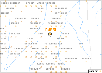
Djési (Benin)Djési is a town in Benin. An overview map of the region around Djési is displayed below.
regional and 3d topo map of Djési, Benin ::
Djési airports ::
The nearest airport is COO - Cotonou Cadjehoun, located 123.2 km south east of Djési.
Other airports nearby include LFW - Lome Gnassingbe Eyadema Intl (155.1 km south west), LOS - Lagos Murtala Muhammed (175.8 km south east), Nearby towns ::
Tokpota (1.9km north) //
Amavédagon (1.9km north) //
Emayou (1.9km north) //
Komé (1.9km north) //
Agounogon (3.7km east) //
Foki (3.7km west) //
Pota (3.7km north) //
Ahouamé (4.1km south east) //
Sakété (4.1km south east) //
Agbengnisoé (4.1km north east) //
Aligoudo (4.1km south west) //
Ouedjologon (4.1km south east) //
Yé (4.1km south west) //
Sopa-Tangagon (4.1km north east) //
Sopa (4.1km north east) //
Dona (5.2km north east) //
Kozokamé (5.6km north) //
Tchiko (5.5km east) //
Akodéhao (5.6km south) //
Agblomé (5.6km south) //
Agbamégon (5.9km north) //
Tosougon (5.9km north) //
Agbétogagon (5.9km north) //
Sousougon (5.8km west) //
Djidja (5.9km south) //
Madjavi (5.9km south) //
Avogbè (6.7km south east) //
Pota (6.7km south west) //
Zobasagon (6.6km north west) //
[all distances 'as the bird flies' and approximate] 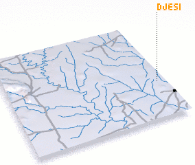 Places with similar names to Djési, Benin ::
Disclaimer :: Information on this page comes without warranty of any kind |
||
|
Where is Djési? Elevation and coordinates ::
Latitude (lat): 7°23'0"N Longitude (lon): 1°57'0"E
Elevation (approx.): 142m (map arrows pan, magnifying glasses zoom) |
||
|
Visiting Djési? Hotel/Accommodation ::
Book a hotel in Djési Travel Guide ::
Buy a travel guide for Benin rental cars ::
car rental offers GPS waypoint ::
download a GPX waypoint (PoI) of Djési for your GPS receiver
|
||