|
search place name
|
||
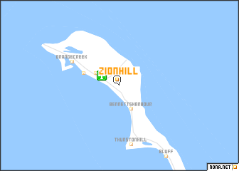
Zion Hill (Cat Island, Bahamas, The)Zion Hill is a town in the Cat Island region of Bahamas, The. An overview map of the region around Zion Hill is displayed below.
regional and 3d topo map of Zion Hill, Bahamas, The ::
Zion Hill airports ::
The nearest airport is RSD - Rock Sound, located 61.5 km north west of Zion Hill.
Other airports nearby include GHB - Governor's Harbor Governors Harbour (101.0 km north west), GGT - Great Exuma Exuma Intl (119.0 km south), SML - Stella Maris (121.0 km south), GGT - George Town (128.1 km south), Nearby towns ::
Dumfries (2.5km north west) //
The Lot (3.8km north west) //
Bennettʼs Harbour (4.1km south east) //
Arthurʼs Town (5.4km west) //
Bain Town (7.7km north west) //
Orange Creek (7.7km north west) //
[all distances 'as the bird flies' and approximate] 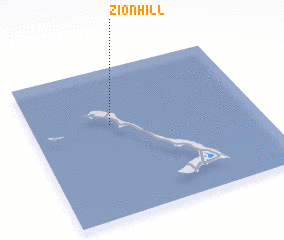 Places with similar names to Zion Hill, Bahamas, The ::
// Snow Hill (US)
// Snow Hill (US)
// Zion Hill (US)
// Snow Hill (US)
// Snow Hill (US)
// Sun Hill (US)
// Sun Hill (US)
// Sunny Hill (US)
// Sunny Hill (US)
// Snow Hill (US)
Disclaimer :: Information on this page comes without warranty of any kind |
||
|
Where is Zion Hill? Elevation and coordinates ::
Latitude (lat): 24°37'0"N Longitude (lon): 75°39'0"W
(map arrows pan, magnifying glasses zoom) |
||
|
Visiting Zion Hill? Hotel/Accommodation ::
Book a hotel in Zion Hill Travel Guide ::
rental cars ::
car rental offers GPS waypoint ::
download a GPX waypoint (PoI) of Zion Hill for your GPS receiver
|
||