|
search place name
|
||
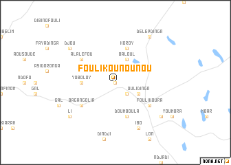
Fouli Kounounou (Lac, Chad)Fouli Kounounou is a town in the Lac region of Chad. An overview map of the region around Fouli Kounounou is displayed below.
regional and 3d topo map of Fouli Kounounou, Chad ::
Fouli Kounounou airports ::
The nearest airport is NDJ - N'djamena Ndjamena Hassan Djamous, located 201.4 km south of Fouli Kounounou.
Nearby towns ::
Mbou (0.0km north) //
Gaya (2.6km south east) //
Baloul (4.1km north east) //
Oulidinga (4.0km south east) //
Yoboloy (5.4km west) //
Doumboula (5.8km south) //
Koroy (5.8km north) //
Alaléfou (6.5km north west) //
Baga Kouka (6.5km south west) //
Baga Ngolia (6.5km south west) //
Fouli Koura (6.5km south east) //
Ibo (8.2km south east) //
Délèp Dinga (9.2km north east) //
Dabou (9.1km south east) //
Li (9.1km south west) //
Djou (9.1km north west) //
[all distances 'as the bird flies' and approximate] 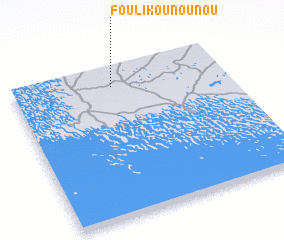 Places with similar names to Fouli Kounounou, Chad ::
Disclaimer :: Information on this page comes without warranty of any kind |
||
|
Where is Fouli Kounounou? Elevation and coordinates ::
Latitude (lat): 13°52'0"N Longitude (lon): 14°28'0"E
Elevation (approx.): 299m (map arrows pan, magnifying glasses zoom) |
||
|
Visiting Fouli Kounounou? Hotel/Accommodation ::
Book a hotel in Fouli Kounounou Travel Guide ::
Buy a travel guide for Chad rental cars ::
car rental offers GPS waypoint ::
download a GPX waypoint (PoI) of Fouli Kounounou for your GPS receiver
|
||