|
search place name
|
||
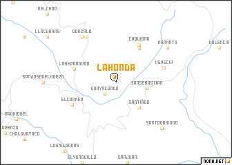
La Honda (Cauca, Colombia)La Honda is a town in the Cauca region of Colombia. An overview map of the region around La Honda is displayed below.
regional and 3d topo map of La Honda, Colombia ::
La Honda airports ::
The nearest airport is PPN - Popayan Guillermo Leon Valencia, located 70.7 km north of La Honda.
Other airports nearby include PSO - Pasto Antonio Narino (72.9 km south west), FLA - Florencia Gustavo Artunduaga Paredes (142.3 km east), GPI - Guapi Juan Casiano (144.3 km north west), IPI - Ipiales San Luis (144.9 km south west), Nearby towns ::
Guayacundo (2.6km south west) //
San Sebastián (5.1km east) //
Santiago (5.5km south east) //
Dominguillo (6.7km north east) //
Caquiona (7.1km north east) //
La Herradura (7.1km west) //
El Carmen (8.0km south west) //
Venecia (8.2km east) //
Almaguer (8.8km north west) //
Gonzalo (9.3km north west) //
Marmato (10.0km north east) //
Santo Domingo (10.5km south east) //
[all distances 'as the bird flies' and approximate] 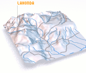 Places with similar names to La Honda, Colombia ::
Disclaimer :: Information on this page comes without warranty of any kind |
||
|
Where is La Honda? Elevation and coordinates ::
Latitude (lat): 1°51'0"N Longitude (lon): 76°49'0"W
Elevation (approx.): 1779m (map arrows pan, magnifying glasses zoom) |
||
|
Visiting La Honda? Hotel/Accommodation ::
Book a hotel in La Honda Travel Guide ::
Buy a travel guide for Colombia rental cars ::
car rental offers GPS waypoint ::
download a GPX waypoint (PoI) of La Honda for your GPS receiver
|
||