|
search place name
|
||
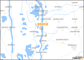
La María (Cesar, Colombia)La María is a town in the Cesar region of Colombia. An overview map of the region around La María is displayed below.
regional and 3d topo map of La María, Colombia ::
La María airports ::
The nearest airport is OCV - Ocana Aguas Claras, located 43.8 km east of La María.
Other airports nearby include CUC - Cucuta Camilo Daza (145.5 km east), EJA - Barrancabermeja Yariguies (150.4 km south), BGA - Bucaramanga Palonegro (152.3 km south east), SVZ - San Antonio Del Tachira (156.4 km south east), Nearby towns ::
Los Obispos (1.9km south) //
La Esperanza (1.9km south) //
Concordia (2.6km south east) //
Puerto Viejo (3.7km south) //
Leguía (4.1km south west) //
Mirabien (4.1km south west) //
Los Guásimos (4.1km north east) //
Babilonia (5.6km north) //
Gamarra (6.1km south) //
Puerto Caimital (7.4km north) //
Palenquillo (7.6km north) //
Las Puntas (7.6km north) //
Agua Blanca (8.2km north east) //
[all distances 'as the bird flies' and approximate] 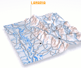 Places with similar names to La María, Colombia ::
Disclaimer :: Information on this page comes without warranty of any kind |
||
|
Where is La María? Elevation and coordinates ::
Latitude (lat): 8°23'0"N Longitude (lon): 73°45'0"W
Elevation (approx.): 31m (map arrows pan, magnifying glasses zoom) |
||
|
Visiting La María? Hotel/Accommodation ::
Book a hotel in La María Travel Guide ::
Buy a travel guide for Colombia rental cars ::
car rental offers GPS waypoint ::
download a GPX waypoint (PoI) of La María for your GPS receiver
|
||