|
search place name
|
||
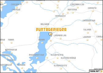
Punta de Piedra (Magdalena, Colombia)Punta de Piedra is a town in the Magdalena region of Colombia. An overview map of the region around Punta de Piedra is displayed below.
regional and 3d topo map of Punta de Piedra, Colombia ::
Punta de Piedra airports ::
The nearest airport is BAQ - Barranquilla Ernesto Cortissoz, located 79.8 km north of Punta de Piedra.
Other airports nearby include CTG - Cartagena Rafael Nunez (92.0 km west), MGN - Magangue Baracoa (99.0 km south), CZU - Corozal Las Brujas (111.6 km south west), SMR - Santa Marta Simon Bolivar (117.8 km north east), Nearby towns ::
Capuchino (1.6km south) //
Las Panelas (3.3km east) //
Bomba (4.1km south west) //
Bálsamo (4.1km north west) //
Henequén (7.1km north east) //
Piedra de Moler (7.9km south) //
El Contento (8.2km south) //
Los Cerritos (9.2km north east) //
Piedra Pintada (9.4km south west) //
Diluvio (10.5km north east) //
Montería (11.6km north east) //
[all distances 'as the bird flies' and approximate] 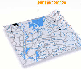 Places with similar names to Punta de Piedra, Colombia ::
// Ponta de Pedra (BR)
// Ponte de Pedra (BR)
// Ponte de Pedra (BR)
// Ponte de Pedra (BR)
// Punta de Piedra (CL)
// Punta de Piedra (CO)
// Puente de Piedra (CR)
// Punta de Piedra (EC)
// Punta de Piedra (EC)
// Punta de Piedra (EC)
Disclaimer :: Information on this page comes without warranty of any kind |
||
|
Where is Punta de Piedra? Elevation and coordinates ::
Latitude (lat): 10°10'15"N Longitude (lon): 74°43'10"W
Elevation (approx.): 11m (map arrows pan, magnifying glasses zoom) |
||
|
Visiting Punta de Piedra? Hotel/Accommodation ::
Book a hotel in Punta de Piedra Travel Guide ::
Buy a travel guide for Colombia rental cars ::
car rental offers GPS waypoint ::
download a GPX waypoint (PoI) of Punta de Piedra for your GPS receiver
|
||