|
search place name
|
||
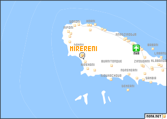
Miréréni (Mohéli, Comoros)Miréréni is a town in the Mohéli region of Comoros. An overview map of the region around Miréréni is displayed below.
regional and 3d topo map of Miréréni, Comoros ::
Miréréni airports ::
The nearest airport is NWA - Moheli Bandaressalam, located 11.9 km east of Miréréni.
Other airports nearby include AJN - Anjouan Ouani (86.4 km east), HAH - Moroni Prince Said Ibrahim (96.8 km north west), DZA - Dzaoudzi Pamandzi (184.1 km east), Nearby towns ::
Ouallah (0.6km south east) //
Mirémani (2.3km south east) //
Damou (2.6km north west) //
Ndrondroni (3.4km south east) //
Miringoni (3.8km north west) //
Chikoni (5.0km north west) //
Hamba (6.0km north west) //
Buanitonque (6.3km east) //
Kobela (6.5km north west) //
Ngamaroumbo (6.8km north) //
Mifoni (7.2km north west) //
Nioumachoua (7.5km south east) //
Gnambo Yamaoré (7.9km north) //
Domoni (7.9km north) //
Fongapepo (8.0km north) //
Hoani (8.0km north) //
Mbatsé (8.0km north east) //
Mtakoudja (8.2km north east) //
Guamarumbo (8.3km north) //
[all distances 'as the bird flies' and approximate]  Places with similar names to Miréréni, Comoros ::
// Maria Rain (AT)
// Maria Rain (DE)
// Morăreni (RO)
// Morăreni (RO)
// Morăreni (RO)
// Mararano (MG)
// Marearano (MG)
// Marerano (MG)
// Marerano (MG)
// Marerano (MG)
Disclaimer :: Information on this page comes without warranty of any kind |
||
|
Where is Miréréni? Elevation and coordinates ::
Latitude (lat): 12°19'16"S Longitude (lon): 43°39'35"E
Elevation (approx.): 94m (map arrows pan, magnifying glasses zoom) |
||
|
Visiting Miréréni? Hotel/Accommodation ::
Book a hotel in Miréréni Travel Guide ::
Buy a travel guide for Comoros rental cars ::
car rental offers GPS waypoint ::
download a GPX waypoint (PoI) of Miréréni for your GPS receiver
|
||