|
search place name
|
||
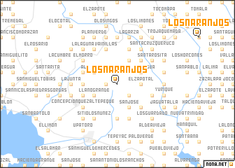
Los Naranjos (Chalatenango, El Salvador)Los Naranjos is a town in the Chalatenango region of El Salvador. An overview map of the region around Los Naranjos is displayed below.
regional and 3d topo map of Los Naranjos, El Salvador ::
Los Naranjos airports ::
The nearest airport is SAL - San Salvador El Salvador Intl, located 76.6 km south of Los Naranjos.
Other airports nearby include SAP - San Pedro Sula La Mesa Intl (181.4 km north east), TGU - Tegucigalpa Toncontin Intl (181.8 km east), GUA - Guatemala City La Aurora (183.0 km west), CBV - Coban (220.7 km north west), Nearby towns ::
El Sicahuite (1.8km west) //
Las Vueltas (2.6km south east) //
El Zapotal (3.6km east) //
Aldea Vieja (4.0km north west) //
Pacayas (4.0km north west) //
Ojos de Agua (4.0km north east) //
Llano Grande (4.0km south west) //
El Tablón (4.1km north east) //
La Ceiba (4.1km south east) //
San José (4.1km south east) //
El Sitio (5.2km north east) //
El Conacaste (5.2km south east) //
Candelaria (5.4km west) //
El Rosario (5.4km west) //
Los Ortiz (5.6km south) //
Comalapa (5.7km west) //
Vainillas (5.8km north) //
El Conacaste (5.7km west) //
La Laguna (5.8km south) //
La Trinidad (5.8km north) //
Coyolar (5.7km east) //
Sitio Los Núñez (6.6km south west) //
La Cuchilla (6.6km north west) //
San José (6.6km north west) //
El Morro (6.5km north west) //
Los Robles (6.6km north east) //
Santa Rosita (6.5km north east) //
Concepción Quezaltepeque (6.5km south west) //
El Ciprés (7.4km north) //
[all distances 'as the bird flies' and approximate]  Places with similar names to Los Naranjos, El Salvador ::
// Los Naranjos (PA)
// Los Naranjos (PA)
// Los Naranjos (PA)
// Los Naranjos (PA)
// Los Naranjos (PA)
// Los Naranjos (PA)
// Los Naranjos (CU)
// Los Naranjos (CO)
// Los Naranjos (CO)
// Los Naranjos (CO)
Disclaimer :: Information on this page comes without warranty of any kind |
||
|
Where is Los Naranjos? Elevation and coordinates ::
Latitude (lat): 14°7'0"N Longitude (lon): 88°54'0"W
Elevation (approx.): 1231m (map arrows pan, magnifying glasses zoom) |
||
|
Visiting Los Naranjos? Hotel/Accommodation ::
Book a hotel in Los Naranjos Travel Guide ::
Buy a travel guide for El Salvador rental cars ::
car rental offers GPS waypoint ::
download a GPX waypoint (PoI) of Los Naranjos for your GPS receiver
|
||