|
search place name
|
||
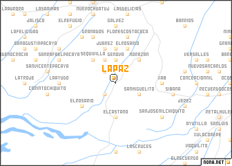
La Paz (Quetzaltenango, Guatemala)La Paz is a town in the Quetzaltenango region of Guatemala. An overview map of the region around La Paz is displayed below.
regional and 3d topo map of La Paz, Guatemala ::
La Paz airports ::
The nearest airport is TAP - Tapachula Intl, located 62.3 km west of La Paz.
Other airports nearby include GUA - Guatemala City La Aurora (140.7 km east), CBV - Coban (182.0 km north east), TGZ - Tuxtla Gutierrez Angel Albino Corzo (253.6 km north west), Nearby towns ::
Bolívar (2.6km south west) //
Guadalupe (2.6km north west) //
Génova (3.7km north) //
Las Ánimas (4.0km south east) //
San Miguelito (4.0km south east) //
Los Paz (4.1km north west) //
Morazán (5.2km north east) //
Sequivillá (5.2km north west) //
El Castaño (5.6km south) //
El Manatial (5.6km north) //
El Rosario (5.8km north) //
Juárez (5.8km north) //
El Rosario (6.5km south west) //
Xab (7.2km east) //
Flores Costa Cuca (7.6km north) //
Granados (8.2km north west) //
San José Nil Chiquito (9.1km south east) //
Barrios (9.2km north west) //
[all distances 'as the bird flies' and approximate] 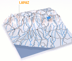 Places with similar names to La Paz, Guatemala ::
Disclaimer :: Information on this page comes without warranty of any kind |
||
|
Where is La Paz? Elevation and coordinates ::
Latitude (lat): 14°35'0"N Longitude (lon): 91°50'0"W
Elevation (approx.): 216m (map arrows pan, magnifying glasses zoom) |
||
|
Visiting La Paz? Hotel/Accommodation ::
Book a hotel in La Paz Travel Guide ::
Buy a travel guide for Guatemala rental cars ::
car rental offers GPS waypoint ::
download a GPX waypoint (PoI) of La Paz for your GPS receiver
|
||