|
search place name
|
||
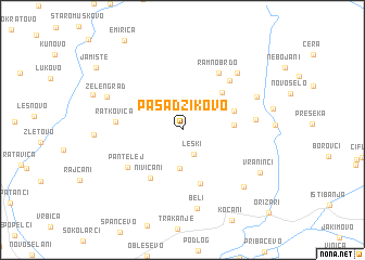
Pasadžikovo (Macedonia, The Republic of)Pasadžikovo is a town in Macedonia, The Republic of. An overview map of the region around Pasadžikovo is displayed below.
regional and 3d topo map of Pasadžikovo, Macedonia, The Republic of ::
Pasadžikovo airports ::
The nearest airport is SKP - Skopje, located 61.9 km west of Pasadžikovo.
Other airports nearby include SOF - Sofia (115.3 km north east), PRN - Pristina (126.9 km north west), INI - Nis (154.4 km north), OHD - Ohrid (163.2 km south west), Nearby towns ::
Leški (2.7km south) //
Poljana (3.9km south) //
Suvo Brdo (3.7km north east) //
Jastrebnik (4.0km east) //
Lisje Brdo (4.9km north east) //
Babište (4.4km north east) //
Crvena Niva (5.7km south) //
Nivičani (5.5km south west) //
Pantelej (5.6km south west) //
Ratkovica (5.2km west) //
Ramno Brdo (6.5km north east) //
Polaki (6.3km north east) //
Skorovo (5.7km east) //
Borovo (7.2km north east) //
Beli (8.1km south) //
Kočanik (6.6km north east) //
Zelengrad (6.7km north west) //
Pripor (7.4km south east) //
Vraninci (7.3km south east) //
Jamište (9.2km north west) //
[all distances 'as the bird flies' and approximate]  Places with similar names to Pasadžikovo, Macedonia, The Republic of :: Disclaimer :: Information on this page comes without warranty of any kind |
||
|
Where is Pasadžikovo? Elevation and coordinates ::
Latitude (lat): 42°0'0"N Longitude (lon): 22°22'0"E
Elevation (approx.): 889m (map arrows pan, magnifying glasses zoom) |
||
|
Visiting Pasadžikovo? Hotel/Accommodation ::
Book a hotel in Pasadžikovo Travel Guide ::
rental cars ::
car rental offers GPS waypoint ::
download a GPX waypoint (PoI) of Pasadžikovo for your GPS receiver
|
||