|
search place name
|
||
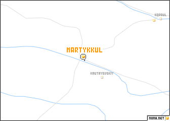
Martyk-Kulʼ (Kökshetaū, Kazakhstan)Martyk-Kulʼ is a town in the Kökshetaū region of Kazakhstan. An overview map of the region around Martyk-Kulʼ is displayed below.
regional and 3d topo map of Martyk-Kulʼ, Kazakhstan ::
Martyk-Kulʼ airports ::
The nearest airport is AKX - Aktyubinsk, located 98.1 km north west of Martyk-Kulʼ.
Nearby towns ::
Kautayevskiy (4.4km south east) //
[all distances 'as the bird flies' and approximate]  Places with similar names to Martyk-Kulʼ, Kazakhstan ::
// Muritgale (MM)
// Mertekli (TR)
// Mertekli (TR)
// Muratçalı (TR)
// Muratkolu (TR)
// Morād Qolī (IR)
// Morād Qolī (IR)
// Mard Gul (PK)
// Mard Kalā (AF)
// Martikkala (FI)
Disclaimer :: Information on this page comes without warranty of any kind |
||
|
Where is Martyk-Kulʼ? Elevation and coordinates ::
Latitude (lat): 49°54'0"N Longitude (lon): 58°28'0"E
Elevation (approx.): 326m (map arrows pan, magnifying glasses zoom) |
||
|
Visiting Martyk-Kulʼ? Hotel/Accommodation ::
Book a hotel in Martyk-Kulʼ Travel Guide ::
Buy a travel guide for Kazakhstan rental cars ::
car rental offers GPS waypoint ::
download a GPX waypoint (PoI) of Martyk-Kulʼ for your GPS receiver
|
||