|
search place name
|
||
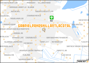
Gabriel Ramos Millán Tlacotal (Distrito Federal, Mexico)Gabriel Ramos Millán Tlacotal is a town in the Distrito Federal region of Mexico. An overview map of the region around Gabriel Ramos Millán Tlacotal is displayed below.
regional and 3d topo map of Gabriel Ramos Millán Tlacotal, Mexico ::
Gabriel Ramos Millán Tlacotal airports ::
The nearest airport is MEX - Mexico City Licenciado Benito Juarez Intl, located 6.6 km north east of Gabriel Ramos Millán Tlacotal.
Other airports nearby include TLC - Toluca Licenciado Adolfo Lopez Mateos Intl (49.2 km west), CVJ - Cuernavaca General Mariano Matamoros (63.1 km south), PBC - Puebla Hermanos Serdan Intl (80.5 km east), PCA - Pachuca Ingeniero Juan Guillermo Villasana (83.7 km north east), Nearby towns ::
Gabriel Ramos Millán Bramadero (0.0km north) //
San Pedro (1.9km north) //
Granjas México (1.9km north) //
Juventino Rosas (1.7km west) //
Iztacalco (2.2km north east) //
Escuadrón 201 (2.5km south west) //
Unidad Modelo (2.5km south west) //
Sector Popular (2.5km south west) //
Héroes de Churubusco (2.5km south west) //
La Cruz (2.5km north east) //
Colonia Agrícola Oriental (2.5km north east) //
Santa Anita (2.5km north west) //
San Andrés Tetepilco (4.0km south west) //
Agrícola Oriental Sur (4.0km north east) //
Prado Churubusco (4.1km south west) //
Mexicaltzingo (4.1km south west) //
Viaducto Piedad (4.0km north west) //
Venustiano Carranza (5.2km north) //
Campestre Churubusco (5.1km south west) //
Juan Escutia (5.1km north east) //
Pantitlán (5.1km north east) //
Pantitlán (5.1km north east) //
Agrícola Oriental Norte (5.1km north east) //
Magdalena Mixhuca (5.2km east) //
Culhuacán (5.6km south) //
Tomatlán (5.6km south) //
México (5.6km east) //
San Francisco Culhuacán (5.8km south) //
Peralvillo (5.6km west) //
[all distances 'as the bird flies' and approximate]  Places with similar names to Gabriel Ramos Millán Tlacotal, Mexico :: Disclaimer :: Information on this page comes without warranty of any kind |
||
|
Where is Gabriel Ramos Millán Tlacotal? Elevation and coordinates ::
Latitude (lat): 19°23'0"N Longitude (lon): 99°6'0"W
Elevation (approx.): 2234m (map arrows pan, magnifying glasses zoom) |
||
|
Visiting Gabriel Ramos Millán Tlacotal? Hotel/Accommodation ::
Book a hotel in Gabriel Ramos Millán Tlacotal Travel Guide ::
Buy a travel guide for Mexico rental cars ::
car rental offers GPS waypoint ::
download a GPX waypoint (PoI) of Gabriel Ramos Millán Tlacotal for your GPS receiver
|
||