|
search place name
|
||
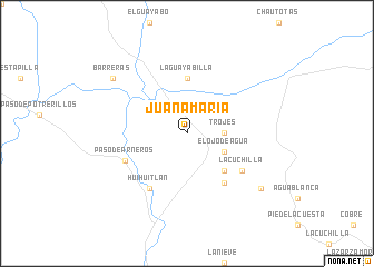
Juana María (Michoacán de Ocampo, Mexico)Juana María is a town in the Michoacán de Ocampo region of Mexico. An overview map of the region around Juana María is displayed below.
regional and 3d topo map of Juana María, Mexico ::
Juana María airports ::
The nearest airport is CLQ - Colima, located 44.0 km north west of Juana María.
Other airports nearby include ZLO - Manzanillo Playa De Oro Intl (127.6 km west), UPN - Uruapan Licenciado Y Gen Ignacio Lopez Rayon (148.8 km east), LZC - Lazard Cardenas Lazaro Cardenas (159.0 km south east), ZMM - Zamora (168.1 km north east), Nearby towns ::
Trojes (3.5km east) //
El Ojo de Agua (4.0km south east) //
Guásimas (5.1km south east) //
El Salitre (5.6km north) //
La Guayabilla (5.6km north) //
El Maicillo (6.1km south east) //
La Cuchilla (6.4km south east) //
Huihuitlán (6.6km south west) //
Paso de Arneros (6.5km south west) //
Barreras (8.9km north west) //
El Tabaquito (8.9km south east) //
[all distances 'as the bird flies' and approximate] 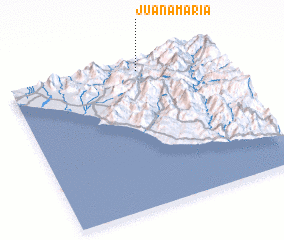 Places with similar names to Juana María, Mexico ::
// Juana María (CU)
// Jiana Mare (RO)
// Jinámar (ES)
// Jeno Umera (ET)
// Juana María (MX)
// Juana María (PE)
// Jean Marie (HT)
// Jeanmaire (AR)
// Geenemeer (BE)
Disclaimer :: Information on this page comes without warranty of any kind |
||
|
Where is Juana María? Elevation and coordinates ::
Latitude (lat): 18°56'0"N Longitude (lon): 103°22'0"W
Elevation (approx.): 316m (map arrows pan, magnifying glasses zoom) |
||
|
Visiting Juana María? Hotel/Accommodation ::
Book a hotel in Juana María Travel Guide ::
Buy a travel guide for Mexico rental cars ::
car rental offers GPS waypoint ::
download a GPX waypoint (PoI) of Juana María for your GPS receiver
|
||