|
search place name
|
||
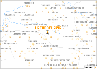
La Candelaría (México, Mexico)La Candelaría is a town in the México region of Mexico. An overview map of the region around La Candelaría is displayed below.
regional and 3d topo map of La Candelaría, Mexico ::
La Candelaría airports ::
The nearest airport is TLC - Toluca Licenciado Adolfo Lopez Mateos Intl, located 96.9 km north east of La Candelaría.
Other airports nearby include CVJ - Cuernavaca General Mariano Matamoros (118.7 km east), MLM - Morelia General Francisco J Mujica Intl (121.8 km north west), MEX - Mexico City Licenciado Benito Juarez Intl (148.7 km east), UPN - Uruapan Licenciado Y Gen Ignacio Lopez Rayon (181.6 km west), Nearby towns ::
Los Bancos (1.3km south east) //
Los Ocotes (2.1km south west) //
Luvianos (2.6km south west) //
El Copalito (2.8km west) //
El Rincón (2.9km north) //
San Simón (2.8km east) //
Piedra Grande (3.2km north east) //
Llano de Felipa (3.5km west) //
El Infiernillo (4.0km south east) //
La Minita (4.0km north east) //
El Tecuán (4.0km north west) //
El Puerto (5.0km north) //
Las Lajas (5.3km south west) //
Potrero de Palmarillos (5.2km north west) //
Los Hormigueros (5.6km south) //
Santa Rosa (5.7km north east) //
El Limón (6.4km north west) //
Rincón de Arrayanes (6.7km south) //
Hermiltepec (6.7km north) //
El Morro (6.7km south west) //
El Reparo (6.8km south west) //
Piedra Colorada (7.0km west) //
El Sesteadero (7.1km west) //
La Estancia (7.3km west) //
Acatitlán (7.7km north east) //
Jalpa (7.9km north) //
Carrizal (8.0km south west) //
Las Juntas (8.4km west) //
Cruz de Clavos (8.8km north) //
[all distances 'as the bird flies' and approximate]  Places with similar names to La Candelaría, Mexico ::
// La Candelaria (PA)
// La Candelaria (PA)
// La Candelaria (PA)
// La Candelaria (PA)
// La Candelaria (PA)
// La Candelaria (PA)
// La Candelaria (CU)
// La Candelaria (CU)
// La Candelaria (CU)
// La Candelaria (CU)
Disclaimer :: Information on this page comes without warranty of any kind |
||
|
Where is La Candelaría? Elevation and coordinates ::
Latitude (lat): 18°56'0"N Longitude (lon): 100°23'0"W
Elevation (approx.): 1436m (map arrows pan, magnifying glasses zoom) |
||
|
Visiting La Candelaría? Hotel/Accommodation ::
Book a hotel in La Candelaría Travel Guide ::
Buy a travel guide for Mexico rental cars ::
car rental offers GPS waypoint ::
download a GPX waypoint (PoI) of La Candelaría for your GPS receiver
|
||