|
search place name
|
||
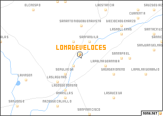
Loma de Veloces (Jalisco, Mexico)Loma de Veloces is a town in the Jalisco region of Mexico. An overview map of the region around Loma de Veloces is displayed below.
regional and 3d topo map of Loma de Veloces, Mexico ::
Loma de Veloces airports ::
The nearest airport is AGU - Aguascalientes Jesus Teran Intl, located 55.2 km north west of Loma de Veloces.
Other airports nearby include BJX - Del Bajio Guanajuato Intl (62.8 km south east), SLP - San Luis Potosi Ponciano Arriaga Intl (135.3 km north east), ZMM - Zamora (157.3 km south), GDL - Guadalajara Don Miguel Hidalgo Y Costilla Intl (178.5 km south west), Nearby towns ::
Santa Elena (2.5km south west) //
San Fandila (4.1km north east) //
Cieneguilla (4.1km north west) //
Sepúlveda (5.1km south west) //
La Palma de Arriba (5.5km east) //
San Antonio de Buenavista (7.4km north) //
Las Lagunas (7.6km south west) //
Daga de Moreno (7.8km south east) //
Lagos de Moreno (8.2km south west) //
[all distances 'as the bird flies' and approximate] 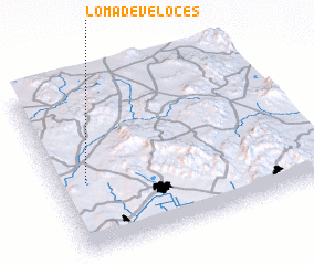 Places with similar names to Loma de Veloces, Mexico :: Disclaimer :: Information on this page comes without warranty of any kind |
||
|
Where is Loma de Veloces? Elevation and coordinates ::
Latitude (lat): 21°25'0"N Longitude (lon): 101°53'0"W
Elevation (approx.): 1887m (map arrows pan, magnifying glasses zoom) |
||
|
Visiting Loma de Veloces? Hotel/Accommodation ::
Book a hotel in Loma de Veloces Travel Guide ::
Buy a travel guide for Mexico rental cars ::
car rental offers GPS waypoint ::
download a GPX waypoint (PoI) of Loma de Veloces for your GPS receiver
|
||