|
search place name
|
||
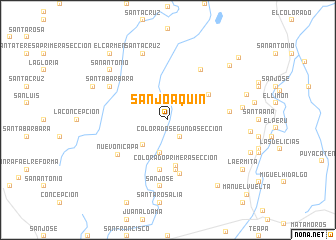
San Joaquin (Tabasco, Mexico)San Joaquin is a town in the Tabasco region of Mexico. An overview map of the region around San Joaquin is displayed below.
regional and 3d topo map of San Joaquin, Mexico ::
San Joaquin airports ::
The nearest airport is VSA - Villahermosa C P A Carlos Rovirosa Intl, located 43.6 km north east of San Joaquin.
Other airports nearby include TGZ - Tuxtla Gutierrez Angel Albino Corzo (122.3 km south), MTT - Minatitlan (170.1 km west), CME - Ciudad Del Carmen Intl (170.9 km north east), Nearby towns ::
Colorado Segunda Sección (2.3km south east) //
San Isidro (3.8km south) //
Blanquillo Segunda Sección (3.8km south west) //
Colorado Primera Sección (5.2km south) //
Hermenegildo Galeana Tercera Sección (5.2km north east) //
San Rafael (5.6km south) //
Belisario Domínguez (5.6km south) //
Juan Aldama (6.2km south) //
Andrés Quintana Roo (6.6km north east) //
Nuevo Nicapa (6.6km south west) //
Hermenegildo Galeana Primera Sección (6.7km east) //
Santa Bárbara (7.2km north west) //
San José (7.5km south) //
Santa Cruz (7.9km north) //
Hermenegildo Galeana Segunda Sección (8.1km east) //
San Antonio (8.3km north west) //
San Antonio (8.8km north west) //
Santa Irene Alvarado (9.0km north east) //
E. Pratz (8.8km east) //
Ignacio Allende Primera Sección (9.1km south east) //
El Carmen (9.7km north west) //
La Ermita (9.7km south east) //
Maríano Pedrero (10.2km north east) //
Manuel Vuelta (11.8km south east) //
[all distances 'as the bird flies' and approximate] 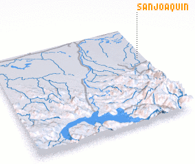 Places with similar names to San Joaquin, Mexico ::
// San Joaquin (BZ)
// San Joaquin (US)
// San Joaquín (PA)
// San Joaquín (CU)
// San Joaquín (CU)
// San Joaquín (CU)
// San Joaquín (CU)
// San Joaquín (CU)
// San Joaquín (CU)
// San Joaquín (CU)
Disclaimer :: Information on this page comes without warranty of any kind |
||
|
Where is San Joaquin? Elevation and coordinates ::
Latitude (lat): 17°40'0"N Longitude (lon): 93°2'30"W
Elevation (approx.): 20m (map arrows pan, magnifying glasses zoom) |
||
|
Visiting San Joaquin? Hotel/Accommodation ::
Book a hotel in San Joaquin Travel Guide ::
Buy a travel guide for Mexico rental cars ::
car rental offers GPS waypoint ::
download a GPX waypoint (PoI) of San Joaquin for your GPS receiver
|
||