|
search place name
|
||
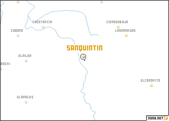
San Quintin (Sonora, Mexico)San Quintin is a town in the Sonora region of Mexico. An overview map of the region around San Quintin is displayed below.
regional and 3d topo map of San Quintin, Mexico ::
San Quintin airports ::
The nearest airport is FHU - Fort Huachuca Sierra Vista Muni Libby Aaf, located 218.4 km north west of San Quintin.
Nearby towns ::
Ciénaga Baja (9.8km north east) //
[all distances 'as the bird flies' and approximate]  Places with similar names to San Quintin, Mexico ::
// San Quentin (US)
// San Quintín (ES)
// Sinacantán (GT)
// San Quintín (MX)
// San Quintín (MX)
// San Quintín (MX)
// Zinacantán (MX)
// Zangon Touno (NE)
// San Quintín (VE)
// San-k'an-tien (TW)
Disclaimer :: Information on this page comes without warranty of any kind |
||
|
Where is San Quintin? Elevation and coordinates ::
Latitude (lat): 30°9'0"N Longitude (lon): 108°47'0"W
Elevation (approx.): 1471m (map arrows pan, magnifying glasses zoom) |
||
|
Visiting San Quintin? Hotel/Accommodation ::
Book a hotel in San Quintin Travel Guide ::
Buy a travel guide for Mexico rental cars ::
car rental offers GPS waypoint ::
download a GPX waypoint (PoI) of San Quintin for your GPS receiver
|
||