|
search place name
|
||
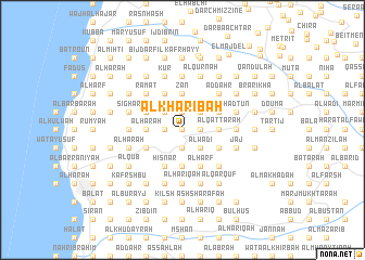
Al Khāribah (Liban-Nord, Lebanon)Al Khāribah is a town in the Liban-Nord region of Lebanon. An overview map of the region around Al Khāribah is displayed below.
regional and 3d topo map of Al Khāribah, Lebanon ::
Al Khāribah airports ::
The nearest airport is BEY - Beirut Rafic Hariri Intl, located 46.9 km south west of Al Khāribah.
Other airports nearby include DAM - Damascus Intl (111.2 km south east), RPN - Rosh Pina Mahanaim I Ben Yaakov (134.4 km south), LTK - Latakia Bassel Al Assad Intl (136.3 km north), HFA - Haifa (165.9 km south west), Nearby towns ::
Mazra‘at al Bayyāḑ (0.0km north) //
As Subayyil (0.0km north) //
Mār Māmā (0.0km north) //
Maghārat ‘Ubayd (0.0km north) //
Aḑ Ḑahr (0.0km north) //
Ḩāqil (1.9km south) //
Ḑahr Abī Yāghī (1.5km west) //
Al Maḩmarā (1.5km west) //
Mazra‘at al Wādī (1.9km north) //
Al Jundī (1.9km north) //
Al Waţāʼ (1.5km east) //
Ad Dūq (1.9km north) //
Masraḩ (1.5km west) //
Al Ma‘āwil (1.5km west) //
Ḩayy as Sayyidah (2.4km south east) //
Al Wādī (2.4km south east) //
Ḩayy Mār Isţifān (2.4km south east) //
Miḩmarsh (2.4km north east) //
Ad Dawāwīr (2.4km north west) //
Ḩayy Bayt ‘Aţīyah (2.4km north east) //
Ḩayy Bayt ash Shanā‘irī (2.4km north east) //
Al ‘Alālī (2.4km north east) //
Al Wādī (2.4km north east) //
Ḩarshā (3.1km west) //
Al Mughayyirī (3.1km west) //
Mayfūq (3.1km east) //
Ḑahr al ‘Ayn (3.1km west) //
Ḩārat ash Shamīs (3.1km east) //
Kafr Shillah (3.1km east) //
[all distances 'as the bird flies' and approximate]  Places with similar names to Al Khāribah, Lebanon ::
// Al Khurayb (IQ)
// Al Khirbah (EG)
// Al Khirbah (TN)
// Al Khirbah (LB)
// Al Kharābah (SA)
// Al Khuraybah (SA)
// Al Kharābah (SD)
// Al Khuraybah (JO)
// Al Khuraybah (JO)
// Al Khirbah (LY)
Disclaimer :: Information on this page comes without warranty of any kind |
||
|
Where is Al Khāribah? Elevation and coordinates ::
Latitude (lat): 34°11'0"N Longitude (lon): 35°45'0"E
Elevation (approx.): 688m (map arrows pan, magnifying glasses zoom) |
||
|
Visiting Al Khāribah? Hotel/Accommodation ::
Book a hotel in Al Khāribah Travel Guide ::
Buy a travel guide for Lebanon rental cars ::
car rental offers GPS waypoint ::
download a GPX waypoint (PoI) of Al Khāribah for your GPS receiver
|
||