|
search place name
|
||
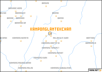
Kampong Lam Tek Chan (Kedah, Malaysia)Kampong Lam Tek Chan is a town in the Kedah region of Malaysia. An overview map of the region around Kampong Lam Tek Chan is displayed below.
regional and 3d topo map of Kampong Lam Tek Chan, Malaysia ::
Kampong Lam Tek Chan airports ::
The nearest airport is AOR - Alor Setar Sultan Abdul Halim, located 50.4 km south west of Kampong Lam Tek Chan.
Other airports nearby include PAN - Pattani (56.5 km north east), HDY - Songkhla Hat Yai Intl (70.1 km north west), NAW - Narathiwat (106.6 km east), LGK - Pulau Langkawi Intl (117.2 km west), Nearby towns ::
Kampung Nam Tiau (0.0km north) //
Kampong Lam Geh (1.8km west) //
Kampung Klok Kla (2.6km south west) //
Ban Nam Chieo (2.6km south east) //
Kampong Haat Nyei (3.7km south) //
Kuan Pelahyun (4.1km south east) //
Kampong Tong Pet (5.6km south) //
Kampong Lam Hong (5.6km south) //
Ban Na (6.7km north east) //
Kampong Peniat (7.6km south) //
Ban Khu Ha (7.6km north) //
Ban Rai (7.6km north) //
Ban Nai Song (10.5km north west) //
[all distances 'as the bird flies' and approximate]  Places with similar names to Kampong Lam Tek Chan, Malaysia :: Disclaimer :: Information on this page comes without warranty of any kind |
||
|
Where is Kampong Lam Tek Chan? Elevation and coordinates ::
Latitude (lat): 6°26'0"N Longitude (lon): 100°47'0"E
Elevation (approx.): 169m (map arrows pan, magnifying glasses zoom) |
||
|
Visiting Kampong Lam Tek Chan? Hotel/Accommodation ::
Book a hotel in Kampong Lam Tek Chan Travel Guide ::
Buy a travel guide for Malaysia rental cars ::
car rental offers GPS waypoint ::
download a GPX waypoint (PoI) of Kampong Lam Tek Chan for your GPS receiver
|
||