|
search place name
|
||
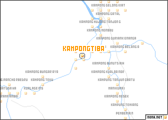
Kampong Tiba (Kelantan, Malaysia)Kampong Tiba is a town in the Kelantan region of Malaysia. An overview map of the region around Kampong Tiba is displayed below.
regional and 3d topo map of Kampong Tiba, Malaysia ::
Kampong Tiba airports ::
The nearest airport is KBR - Kota Bahru Sultan Ismail Petra, located 80.5 km north of Kampong Tiba.
Other airports nearby include TGG - Kuala Terengganu Sultan Mahmud (104.1 km east), NAW - Narathiwat (127.3 km north), IPH - Ipoh Sultan Azlan Shah (154.0 km south west), KTE - Kerteh (172.4 km south east), Nearby towns ::
Kampong Jelapang (0.0km north) //
Kampong Bunut Peteri (0.0km north) //
Kampung Berhala (0.0km north) //
Kampong Mambong (1.8km west) //
Kampong Jeramah (2.6km north east) //
Kampung Berhala (2.6km north west) //
Kampong Pichong (2.6km south west) //
Kampong Raba (2.6km south west) //
Pahi Bawah (4.1km north east) //
Kampong Nior (4.1km north east) //
Kampung Pahi (5.8km east) //
Kampong Bunut Saih (5.8km east) //
Kampong Merbau (6.7km north east) //
Kampong Kuala Anor (6.7km south east) //
Kampung Pasir Lalat (7.6km north) //
Kampung Bintang (8.3km north east) //
Kampong Durian Kenanga (8.3km north east) //
Kampong Tualang (8.3km north east) //
Kampong Hujong Tanjong (8.3km north east) //
Kampong Tanjong Batuisee Kampung Tanjung Batu (9.2km south east) //
Kampung Tanjung Batu (9.2km south east) //
Kampong Manek Urai (9.2km south east) //
Kampong Pangkat Senor (10.5km south east) //
Manik Urai (10.5km south east) //
[all distances 'as the bird flies' and approximate] 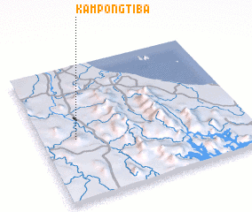 Places with similar names to Kampong Tiba, Malaysia ::
// Kampong Taba (MY)
// Kampong Tabeh (MY)
// Kampong Tabo (MY)
// Kampong Taboh (MY)
// Kampong Teba (MY)
// Kampong Toboh (MY)
// Kampong Tubau (MY)
// Kampung Tubeh (MY)
// Kampungtebu (ID)
// Kampong Gedabu (MY)
Disclaimer :: Information on this page comes without warranty of any kind |
||
|
Where is Kampong Tiba? Elevation and coordinates ::
Latitude (lat): 5°27'0"N Longitude (lon): 102°10'0"E
Elevation (approx.): 109m (map arrows pan, magnifying glasses zoom) |
||
|
Visiting Kampong Tiba? Hotel/Accommodation ::
Book a hotel in Kampong Tiba Travel Guide ::
Buy a travel guide for Malaysia rental cars ::
car rental offers GPS waypoint ::
download a GPX waypoint (PoI) of Kampong Tiba for your GPS receiver
|
||