|
search place name
|
||
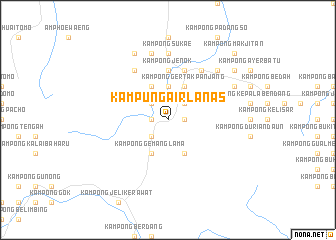
Kampung Air Lanas (Kelantan, Malaysia)Kampung Air Lanas is a town in the Kelantan region of Malaysia. An overview map of the region around Kampung Air Lanas is displayed below.
regional and 3d topo map of Kampung Air Lanas, Malaysia ::
Kampung Air Lanas airports ::
The nearest airport is KBR - Kota Bahru Sultan Ismail Petra, located 62.1 km north east of Kampung Air Lanas.
Other airports nearby include NAW - Narathiwat (82.9 km north), PAN - Pattani (137.1 km north west), TGG - Kuala Terengganu Sultan Mahmud (142.2 km east), IPH - Ipoh Sultan Azlan Shah (160.5 km south west), Nearby towns ::
Kampong Labu (1.8km west) //
Kampong Parit Besar (1.8km west) //
Kampong Kochi (1.8km west) //
Batu Karang (1.8km east) //
Kampong Tua (2.6km south west) //
Kampong Gemang Baharu (2.6km south west) //
Kampong Buloh (2.6km south west) //
Kampong Chelagi (2.6km south west) //
Kampong Sat (2.6km north west) //
Kampong Buyong (2.6km north east) //
Kampong Bukit Nangka (3.7km north) //
Kampong Gemang Lama (4.1km south west) //
Kampong Bukit Susun (4.1km south west) //
Kampong Legeh (4.1km south east) //
Ban Baketa (4.1km north west) //
Kampong Chedok (4.1km north east) //
Kampong Gertak Panjang (4.1km north east) //
Kampong Jenok (5.6km north) //
Kampong Bukit Bunga (5.9km north) //
Ban Bala (6.7km north west) //
Kampong Tilam (6.7km north east) //
Kampung Nibung (6.7km north east) //
Kampong Sukae (7.4km north) //
Ban Buke (7.6km north) //
Kampong Banggol Yek (7.8km north east) //
Kampong Cheyo (8.3km north west) //
Kampong Gual (8.3km north east) //
Kampung Jeduk (9.2km north east) //
Kampong Bechah Butir Nangka (9.2km north east) //
[all distances 'as the bird flies' and approximate] 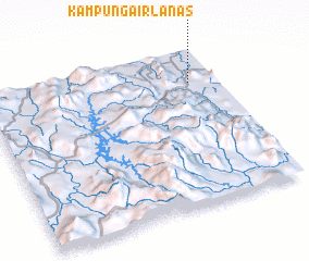 Places with similar names to Kampung Air Lanas, Malaysia :: Disclaimer :: Information on this page comes without warranty of any kind |
||
|
Where is Kampung Air Lanas? Elevation and coordinates ::
Latitude (lat): 5°47'0"N Longitude (lon): 101°53'0"E
Elevation (approx.): 36m (map arrows pan, magnifying glasses zoom) |
||
|
Visiting Kampung Air Lanas? Hotel/Accommodation ::
Book a hotel in Kampung Air Lanas Travel Guide ::
Buy a travel guide for Malaysia rental cars ::
car rental offers GPS waypoint ::
download a GPX waypoint (PoI) of Kampung Air Lanas for your GPS receiver
|
||