|
search place name
|
||
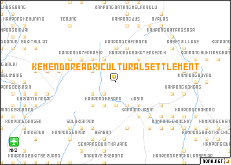
Kemendore Agricultural Settlement (Melaka, Malaysia)Kemendore Agricultural Settlement is a town in the Melaka region of Malaysia. An overview map of the region around Kemendore Agricultural Settlement is displayed below.
regional and 3d topo map of Kemendore Agricultural Settlement, Malaysia ::
Kemendore Agricultural Settlement airports ::
The nearest airport is MKZ - Malacca, located 19.1 km south west of Kemendore Agricultural Settlement.
Other airports nearby include KUL - Kuala Lumpur Intl (88.3 km north west), DUM - Dumai Pinang Kampai (135.2 km south west), JHB - Johor Bahru Sultan Ismail (161.5 km south east), KUA - Kuantan (181.5 km north east), Nearby towns ::
Kampong Kemangkang (2.6km south west) //
Kesang Tua (3.7km south) //
Kelubi (4.1km south east) //
Kampong Ayer Perah (4.1km south east) //
Selandar (4.1km north west) //
Kampong Selandar (4.1km north west) //
Kampong Kesang (4.1km south west) //
Kampong Pondok Kempas (4.1km north west) //
Kampong Kesang Pajak (4.1km south west) //
Kampong Anak Ayer Keroh (5.2km north east) //
Jasin (5.2km south east) //
Kampong Simpang (5.2km south east) //
Kampong Tengah (5.2km north west) //
Kesang Pajak (5.2km south west) //
Kampong Bukit Senggeh (5.6km north) //
Kampong Rejang (5.9km north) //
Kampong Chembong (5.9km north) //
Kampong Jasin (6.7km south east) //
Kampong Ulu Jasin (6.7km south east) //
Kampong Solok Haji Limin (6.7km south east) //
Kampong Ayer Pasir (6.7km north west) //
Kampong Ayer Bangkong (6.7km north west) //
Kampong Anak Ayer Merbau (7.6km south) //
Kampong Simpang Kerayong (7.9km south east) //
Simpang Kerayong (7.9km south east) //
Kampong Ayer Pasir (8.3km north west) //
Kampong Machap Baharu (8.3km north west) //
Gaong Bangkong (8.3km south east) //
Kampong Ayer Panas (8.3km south west) //
[all distances 'as the bird flies' and approximate] 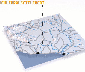 Places with similar names to Kemendore Agricultural Settlement, Malaysia :: Disclaimer :: Information on this page comes without warranty of any kind |
||
|
Where is Kemendore Agricultural Settlement? Elevation and coordinates ::
Latitude (lat): 2°21'0"N Longitude (lon): 102°24'0"E
Elevation (approx.): 56m (map arrows pan, magnifying glasses zoom) |
||
|
Visiting Kemendore Agricultural Settlement? Hotel/Accommodation ::
Book a hotel in Kemendore Agricultural Settlement Travel Guide ::
Buy a travel guide for Malaysia rental cars ::
car rental offers GPS waypoint ::
download a GPX waypoint (PoI) of Kemendore Agricultural Settlement for your GPS receiver
|
||