|
search place name
|
||
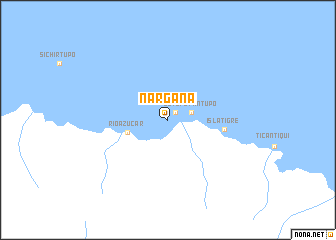
Narganá (San Blas, Panama)Narganá is a town in the San Blas region of Panama. An overview map of the region around Narganá is displayed below.
regional and 3d topo map of Narganá, Panama ::
Narganá airports ::
The nearest airport is PTY - Panama City Tocumen Intl, located 96.3 km south west of Narganá.
Other airports nearby include PAC - Panama Marcos A Gelabert Intl (118.1 km south west), HOW - Howard (125.3 km south west), Nearby towns ::
Corazón de Jesús (1.1km north east) //
Tupile (2.7km east) //
Ustupo Yantupo (2.7km east) //
Río Azúcar (4.7km west) //
Isla Tigre (6.4km east) //
[all distances 'as the bird flies' and approximate]  Places with similar names to Narganá, Panama ::
// Nǝrǝcan (AZ)
// Narigan (MM)
// Narkūnai (LT)
// Narkūnai (LT)
// Narkūnai (LT)
// Narkūnai I (LT)
// Narkūnai II (LT)
// Nereikoniai (LT)
// Noreikoniai (LT)
// Norkūnai (LT)
Disclaimer :: Information on this page comes without warranty of any kind |
||
|
Where is Narganá? Elevation and coordinates ::
Latitude (lat): 9°26'34"N Longitude (lon): 78°35'26"W
Elevation (approx.): -32768m (map arrows pan, magnifying glasses zoom) |
||
|
Visiting Narganá? Hotel/Accommodation ::
Book a hotel in Narganá Travel Guide ::
Buy a travel guide for Panama rental cars ::
car rental offers GPS waypoint ::
download a GPX waypoint (PoI) of Narganá for your GPS receiver
|
||