|
search place name
|
||
Al Najāgh (Arbīl, Iraq)Al Najāgh is a town in the Arbīl region of Iraq. An overview map of the region around Al Najāgh is displayed below.
regional and 3d topo map of Al Najāgh, Iraq ::
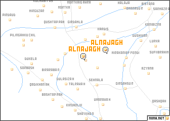
Nearby towns ::
Dawlah Bakrah (0.1km east) //
Ḩamzah Kūr (2.6km north) //
Garah Shaykhān (2.7km south east) //
Chēlabasha (4.6km north) //
Qūl Tappah Ya‘qūb (3.9km north west) //
Al Najāgh (4.2km east) //
Qūl Tappah Rashīd (4.8km west) //
Kerrzoi (5.8km north) //
Seh Nala (5.8km south) //
Gomahgurrī (5.7km north east) //
Tal Rāwah (6.5km south) //
Dūlāsīzah (6.2km south west) //
Kardīs (6.8km north east) //
Girdamla (7.6km north) //
Biʼr ‘Arabān (6.8km south west) //
Būrījah (7.1km east) //
Qūsh Tappah (9.0km north west) //
Girdah Sūr (9.5km south east) //
Bāsh Tappah (10.4km south west) //
[all distances 'as the bird flies' and approximate]  Places with similar names to Al Najāgh, Iraq ::
// Al Najāgh (IQ)
Disclaimer :: Information on this page comes without warranty of any kind |
||
|
Where is Al Najāgh? Elevation and coordinates ::
Latitude (lat): 35°56'32"N Longitude (lon): 44°4'20"E
Elevation (approx.): 392m (map arrows pan, magnifying glasses zoom) |
||
|
Visiting Al Najāgh? Hotel/Accommodation ::
Book a hotel in Al Najāgh Travel Guide ::
Buy a travel guide for Iraq rental cars ::
car rental offers GPS waypoint ::
download a GPX waypoint (PoI) of Al Najāgh for your GPS receiver
|
||