|
search place name
|
||
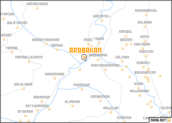
‘Arabakān (As Sulaymānīyah, Iraq)‘Arabakān is a town in the As Sulaymānīyah region of Iraq. An overview map of the region around ‘Arabakān is displayed below.
regional and 3d topo map of ‘Arabakān, Iraq ::
‘Arabakān airports ::
The nearest airport is SDG - Sanandaj, located 134.6 km east of ‘Arabakān.
Other airports nearby include KSH - Bakhtaran Shahid Ashrafi Esfahani (155.9 km south east), Nearby towns ::
Yāsīn ‘Arab (2.1km south west) //
‘Alī Muḩammad (2.2km north west) //
Bāqūbarah (2.2km east) //
Ţūbkhānah (3.4km north) //
Piwaz (3.8km north) //
Shaykh Muḩammad (3.9km south east) //
Tūkeh (4.7km north east) //
Khūrkhūr (6.0km south) //
Garmūk (5.8km north west) //
Darūnī Khān (6.7km south west) //
Zalchah (6.5km east) //
Tappah Qalandarī (6.7km east) //
Dār-ī Imām (7.2km north east) //
Tappah Şūfī (7.3km east) //
Kānī Būrkah (9.0km south) //
Qasrān (8.1km north east) //
Hawrayn Shīkhān (8.1km north west) //
Kānī Qūl (9.0km north east) //
[all distances 'as the bird flies' and approximate] 
Disclaimer :: Information on this page comes without warranty of any kind |
||
|
Where is ‘Arabakān? Elevation and coordinates ::
Latitude (lat): 34°53'57"N Longitude (lon): 45°35'44"E
Elevation (approx.): 319m (map arrows pan, magnifying glasses zoom) |
||
|
Visiting ‘Arabakān? Hotel/Accommodation ::
Book a hotel in ‘Arabakān Travel Guide ::
Buy a travel guide for Iraq rental cars ::
car rental offers GPS waypoint ::
download a GPX waypoint (PoI) of ‘Arabakān for your GPS receiver
|
||