|
search place name
|
||
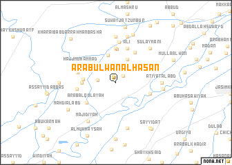
‘Arab ‘Ulwān al Ḩasan (Diyālá, Iraq)‘Arab ‘Ulwān al Ḩasan is a town in the Diyālá region of Iraq. An overview map of the region around ‘Arab ‘Ulwān al Ḩasan is displayed below.
regional and 3d topo map of ‘Arab ‘Ulwān al Ḩasan, Iraq ::
Nearby towns ::
Waysī (1.4km north east) //
Qaryat al ‘Ujaymī (2.4km west) //
Qawām (4.0km north east) //
Sarājiq (4.5km north) //
Ḩumayrah (4.4km west) //
Karīm Khalīl (5.4km north) //
Qal‘at Mullā Khādim (5.6km north) //
Şāliḩ ash Shantaf (4.6km west) //
Muwayliḩ (5.6km north) //
Ḩanashī (5.5km north east) //
‘Arab al Qulay‘ah (5.1km south west) //
Laţīf al Māshī (5.0km east) //
‘Alī (5.8km north) //
Ḩājj Muḩammad (5.4km north west) //
‘Abd Allāh Afandī (5.3km west) //
‘Arab Kāz̧im al Ismā‘īl (5.4km west) //
Tajdārī (6.5km north) //
‘Aţīyat al ‘Abd (6.1km east) //
Tall Abū Turābah (7.4km north) //
Abū Şaydah (7.6km south) //
Huwayrah (7.6km north) //
Marfū‘ (7.6km north) //
Dhiyābah (6.4km east) //
Majīdīyah (7.4km south west) //
Sulaymānī (7.2km north east) //
‘Umaylah (8.1km north) //
Mahdī al ‘Abd (7.8km south west) //
Abū Jisrah (8.7km south east) //
Sayyidāt (9.0km south east) //
[all distances 'as the bird flies' and approximate]  Places with similar names to ‘Arab ‘Ulwān al Ḩasan, Iraq :: Disclaimer :: Information on this page comes without warranty of any kind |
||
|
Where is ‘Arab ‘Ulwān al Ḩasan? Elevation and coordinates ::
Latitude (lat): 33°59'0"N Longitude (lon): 44°46'0"E
Elevation (approx.): 50m (map arrows pan, magnifying glasses zoom) |
||
|
Visiting ‘Arab ‘Ulwān al Ḩasan? Hotel/Accommodation ::
Book a hotel in ‘Arab ‘Ulwān al Ḩasan Travel Guide ::
Buy a travel guide for Iraq rental cars ::
car rental offers GPS waypoint ::
download a GPX waypoint (PoI) of ‘Arab ‘Ulwān al Ḩasan for your GPS receiver
|
||