|
search place name
|
||
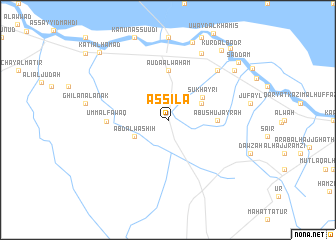
As Sīlā (Dhī Qār, Iraq)As Sīlā is a town in the Dhī Qār region of Iraq. An overview map of the region around As Sīlā is displayed below.
regional and 3d topo map of As Sīlā, Iraq ::
As Sīlā airports ::
The nearest airport is BSR - Basrah Intl, located 166.4 km east of As Sīlā.
Other airports nearby include KWI - Kuwait Intl (274.8 km south east), Nearby towns ::
Shakāhi (3.7km north east) //
Bid‘ah (3.7km north east) //
‘Abd Āl Washīḩ (3.7km south west) //
Şukhayrī (4.1km north east) //
Abū Shujayrah (4.8km east) //
Auda Āl Wahām (5.6km north) //
Umm al Fawāq (5.9km west) //
Abū Shambalānah (7.3km north east) //
Jazīrah (8.1km north east) //
Abū Gharīb (9.0km north) //
Sayyid Jābir (8.4km north east) //
Abū Samāḩ (8.4km north east) //
Kurd al Badr (9.3km north east) //
Şaddām (9.3km north east) //
Ḩusayn al Ḩunaysh (10.0km north east) //
Kāţi‘ Āl Ḩamad (10.0km north west) //
[all distances 'as the bird flies' and approximate] 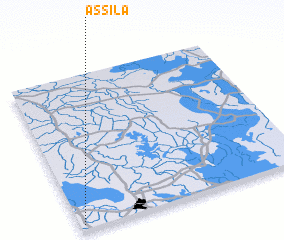 Places with similar names to As Sīlā, Iraq ::
Disclaimer :: Information on this page comes without warranty of any kind |
||
|
Where is As Sīlā? Elevation and coordinates ::
Latitude (lat): 31°2'0"N Longitude (lon): 46°1'0"E
Elevation (approx.): 6m (map arrows pan, magnifying glasses zoom) |
||
|
Visiting As Sīlā? Hotel/Accommodation ::
Book a hotel in As Sīlā Travel Guide ::
Buy a travel guide for Iraq rental cars ::
car rental offers GPS waypoint ::
download a GPX waypoint (PoI) of As Sīlā for your GPS receiver
|
||