|
search place name
|
||
Bayt Dafār (Bābil, Iraq)Bayt Dafār is a town in the Bābil region of Iraq. An overview map of the region around Bayt Dafār is displayed below.
regional and 3d topo map of Bayt Dafār, Iraq ::
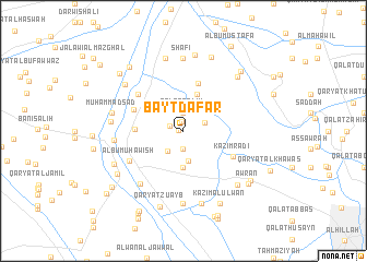
Nearby towns ::
Ālbū Surdī (0.4km west) //
Qaryat Banāt al Ḩasan (0.9km north) //
Shilţāgh (1.3km north west) //
‘Abd al Karīm (1.9km south) //
Qal‘at Sālim (1.9km north) //
Laftat al Ḩusayn (2.1km north east) //
‘Arab al Kuraydāt (2.5km south west) //
Ḩayyūm (3.1km south) //
Qal‘at Salmān Mūsá (3.7km south) //
Qaryat al Mahnādīyah (3.9km north) //
Hātif ‘Abbūd (4.2km west) //
Qal‘at Ḩusayn as Salīm (5.0km north) //
Ālbū Fāris (4.8km north west) //
Kāz̧im Rāḑī (5.1km south east) //
Ālbū Jadīdah (5.4km north west) //
Ālbū Muhāwish (5.6km south west) //
Qaryat ar Rushaywah (6.6km south west) //
Qaryat al Janājah (6.0km west) //
Bayt Sayyid Ḩabīb (7.4km south) //
Shāfī (7.4km north) //
Qaryat al Ḩamdānīyah (6.3km west) //
Muḩammad Sa‘d (6.4km west) //
‘Abbās Mahdī (6.9km north west) //
Shaykh Ḩusayn (7.6km south) //
Muḩammad al Ḩākim (7.6km north) //
Qal‘at Ḩājjī Shukrī (7.3km south east) //
Qaşr al Muhannāwīyah (7.3km north east) //
Qaryat Ālbū ‘Azīz (6.9km south west) //
Qal‘at Ţāmī as Salmān (7.9km north) //
[all distances 'as the bird flies' and approximate] 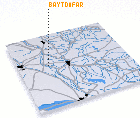 Places with similar names to Bayt Dafār, Iraq :: Disclaimer :: Information on this page comes without warranty of any kind |
||
|
Where is Bayt Dafār? Elevation and coordinates ::
Latitude (lat): 32°35'0"N Longitude (lon): 44°17'0"E
Elevation (approx.): 30m (map arrows pan, magnifying glasses zoom) |
||
|
Visiting Bayt Dafār? Hotel/Accommodation ::
Book a hotel in Bayt Dafār Travel Guide ::
Buy a travel guide for Iraq rental cars ::
car rental offers GPS waypoint ::
download a GPX waypoint (PoI) of Bayt Dafār for your GPS receiver
|
||