|
search place name
|
||
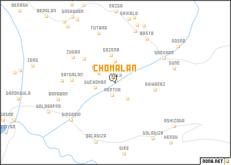
Chōmalān (As Sulaymānīyah, Iraq)Chōmalān is a town in the As Sulaymānīyah region of Iraq. An overview map of the region around Chōmalān is displayed below.
regional and 3d topo map of Chōmalān, Iraq ::
Chōmalān airports ::
The nearest airport is SDG - Sanandaj, located 203.2 km south east of Chōmalān.
Other airports nearby include TBZ - Tabriz Intl (228.1 km north east), Nearby towns ::
Balk (0.3km north east) //
Mērtka (2.1km south) //
Spērō (2.7km north west) //
Bādāwa (3.1km south east) //
Dūchōmān (2.8km west) //
Kulkula (3.5km north) //
Gozena (4.5km north) //
Dargala (5.6km north west) //
Shīwaraz (5.3km east) //
Saydalān (5.7km west) //
Zūdān (6.9km north west) //
Tūtama (8.2km north) //
Qalāwa (7.0km west) //
Basta (8.2km north east) //
Sarkhān (7.5km north east) //
Suragla (8.8km north) //
Singasir (8.4km south west) //
[all distances 'as the bird flies' and approximate] 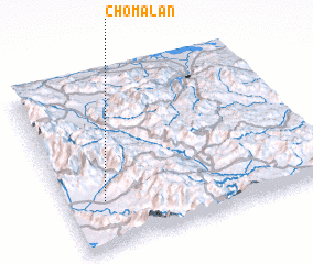 Places with similar names to Chōmalān, Iraq ::
// Chmielno (PL)
// Chmieleń (PL)
// Chmielno (PL)
// Shīmbelīna (ET)
// Chumblín (EC)
// Chimolón (GT)
// Shumilin (KZ)
// Chembalán (MX)
// Chambuleni (ZM)
// Shamlān (IR)
Disclaimer :: Information on this page comes without warranty of any kind |
||
|
Where is Chōmalān? Elevation and coordinates ::
Latitude (lat): 36°16'17"N Longitude (lon): 45°8'52"E
Elevation (approx.): 656m (map arrows pan, magnifying glasses zoom) |
||
|
Visiting Chōmalān? Hotel/Accommodation ::
Book a hotel in Chōmalān Travel Guide ::
Buy a travel guide for Iraq rental cars ::
car rental offers GPS waypoint ::
download a GPX waypoint (PoI) of Chōmalān for your GPS receiver
|
||