|
search place name
|
||
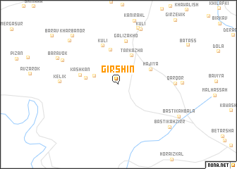
Girshīn (Dahūk, Iraq)Girshīn is a town in the Dahūk region of Iraq. An overview map of the region around Girshīn is displayed below.
regional and 3d topo map of Girshīn, Iraq ::
Girshīn airports ::
The nearest airport is BAL - Batman, located 169.0 km north west of Girshīn.
Other airports nearby include VAN - Van (173.7 km north), Nearby towns ::
Kānī Kark (3.3km north west) //
Tarkazhā (4.8km north) //
Aymalk (4.3km west) //
Qāḑīyah (5.5km north) //
Hājiyā (4.7km north east) //
Kāshkān (5.1km west) //
Kūlī (6.4km north) //
Galī Zākhō (6.9km north) //
Hasanāwā (9.2km north) //
Kūlī (9.2km north) //
Māzrī (8.0km north west) //
Kharbātūr (9.2km north west) //
Kharbanor (9.6km north west) //
Bāstīkah Zirr (9.4km south east) //
[all distances 'as the bird flies' and approximate]  Places with similar names to Girshīn, Iraq ::
// Jursian (ID)
// Jara China (MX)
// Girātiān (PK)
// Gīr Shanni (SY)
// Girchany (BY)
// Gershony (BY)
// Jourchane (FR)
// Jrashen (AM)
// Jrashen (AM)
Disclaimer :: Information on this page comes without warranty of any kind |
||
|
Where is Girshīn? Elevation and coordinates ::
Latitude (lat): 37°0'17"N Longitude (lon): 42°38'5"E
Elevation (approx.): 524m (map arrows pan, magnifying glasses zoom) |
||
|
Visiting Girshīn? Hotel/Accommodation ::
Book a hotel in Girshīn Travel Guide ::
Buy a travel guide for Iraq rental cars ::
car rental offers GPS waypoint ::
download a GPX waypoint (PoI) of Girshīn for your GPS receiver
|
||