|
search place name
|
||
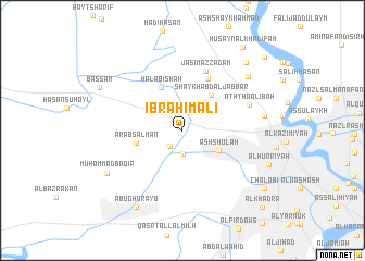
Ibrāhīm ‘Alī (Al Anbār, Iraq)Ibrāhīm ‘Alī is a town in the Al Anbār region of Iraq. An overview map of the region around Ibrāhīm ‘Alī is displayed below.
regional and 3d topo map of Ibrāhīm ‘Alī, Iraq ::
Nearby towns ::
As Salmānīyāt (2.0km south west) //
‘Arab Ḩusayn (2.4km south) //
Ash Shu‘lah (3.7km south east) //
Shaykh ‘Abd al Jabbār (4.4km north east) //
Ḩalābishah (4.7km north west) //
‘Arab Salmān (4.2km west) //
Ḩātim as Sulţān (5.7km north east) //
Jāsim az Zagam (6.4km north) //
Ath Tha‘ālibah (6.4km north east) //
As Sayyid Ţāhāʼ (7.2km east) //
Ḩusayn as Suhayl (7.9km north east) //
Muḩammad Bāqir (7.9km south west) //
Abū Ghurayb (8.8km south west) //
‘Abbūd as Sayyid (8.9km north east) //
Aḩmad al Ḩasan (8.9km north east) //
Bassām (8.4km north west) //
Chalabī (9.2km south east) //
Ḩusayn al Khalīfah (10.0km north east) //
Qaşr Kāz̧im Bāshā (10.3km north east) //
Al Khaḑrāʼ (10.4km south east) //
[all distances 'as the bird flies' and approximate]  Places with similar names to Ibrāhīm ‘Alī, Iraq ::
Disclaimer :: Information on this page comes without warranty of any kind |
||
|
Where is Ibrāhīm ‘Alī? Elevation and coordinates ::
Latitude (lat): 33°23'13"N Longitude (lon): 44°14'27"E
Elevation (approx.): 36m (map arrows pan, magnifying glasses zoom) |
||
|
Visiting Ibrāhīm ‘Alī? Hotel/Accommodation ::
Book a hotel in Ibrāhīm ‘Alī Travel Guide ::
Buy a travel guide for Iraq rental cars ::
car rental offers GPS waypoint ::
download a GPX waypoint (PoI) of Ibrāhīm ‘Alī for your GPS receiver
|
||