|
search place name
|
||
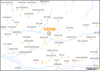
Kānī Bī (As Sulaymānīyah, Iraq)Kānī Bī is a town in the As Sulaymānīyah region of Iraq. An overview map of the region around Kānī Bī is displayed below.
regional and 3d topo map of Kānī Bī, Iraq ::
Kānī Bī airports ::
The nearest airport is SDG - Sanandaj, located 103.6 km south east of Kānī Bī.
Other airports nearby include KSH - Bakhtaran Shahid Ashrafi Esfahani (185.6 km south east), Nearby towns ::
Bīrālah (2.5km south west) //
Sarbirālah (2.9km south west) //
Qishlāq (2.7km east) //
Tarra Tūla (3.5km south) //
Kānī Zulaykhāʼ (3.8km south east) //
Kānī Sard (4.5km south east) //
Dolābi (4.9km north west) //
Waynah (6.2km north) //
Dārū Khān (6.3km north east) //
Khalvazeh (6.6km south) //
Shaykh Dī (6.5km north west) //
Sar Sūrāw (6.0km west) //
Chūīsah (6.2km east) //
Shālataw (6.6km east) //
Narzanah (7.1km south west) //
Qolqoleh (8.5km south) //
Kūkh-e Mīr ‘Os̄mān (7.6km south west) //
Mīrāwah (7.2km west) //
Sāvjī (8.9km south east) //
Shiwa Guizān (9.5km north) //
Mīrgah-e Derīzh (9.9km south east) //
Kānī Harmī (9.7km north west) //
[all distances 'as the bird flies' and approximate] 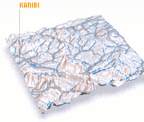 Places with similar names to Kānī Bī, Iraq ::
Disclaimer :: Information on this page comes without warranty of any kind |
||
|
Where is Kānī Bī? Elevation and coordinates ::
Latitude (lat): 35°44'47"N Longitude (lon): 46°2'42"E
Elevation (approx.): 1420m (map arrows pan, magnifying glasses zoom) |
||
|
Visiting Kānī Bī? Hotel/Accommodation ::
Book a hotel in Kānī Bī Travel Guide ::
Buy a travel guide for Iraq rental cars ::
car rental offers GPS waypoint ::
download a GPX waypoint (PoI) of Kānī Bī for your GPS receiver
|
||