|
search place name
|
||
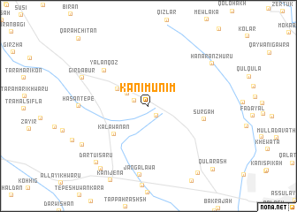
Kānī Munim (As Sulaymānīyah, Iraq)Kānī Munim is a town in the As Sulaymānīyah region of Iraq. An overview map of the region around Kānī Munim is displayed below.
regional and 3d topo map of Kānī Munim, Iraq ::
Kānī Munim airports ::
The nearest airport is SDG - Sanandaj, located 164.3 km east of Kānī Munim.
Other airports nearby include KSH - Bakhtaran Shahid Ashrafi Esfahani (226.0 km south east), Nearby towns ::
Qamar Tali (1.4km south east) //
Dār Tū (1.7km north west) //
Bīskandī (2.8km north west) //
Dārbarū (3.9km north west) //
Kālawānān (5.0km south west) //
Sūrgah (5.9km east) //
Yālānqoz (6.4km north west) //
Jangalāwa (8.7km south) //
Ḩasan Tepe (7.2km west) //
Girdābur (7.8km north west) //
Hanārān Zhūrū (8.4km north east) //
Chāqizh (8.4km south west) //
Dārtū-i Saru (8.9km south west) //
Dār Tū (9.3km south west) //
Bāwamirdah (9.8km south east) //
Qularash (10.3km south east) //
[all distances 'as the bird flies' and approximate] 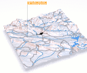 Places with similar names to Kānī Munim, Iraq ::
// Caño Mánamo (VE)
Disclaimer :: Information on this page comes without warranty of any kind |
||
|
Where is Kānī Munim? Elevation and coordinates ::
Latitude (lat): 35°40'8"N Longitude (lon): 45°16'30"E
Elevation (approx.): 982m (map arrows pan, magnifying glasses zoom) |
||
|
Visiting Kānī Munim? Hotel/Accommodation ::
Book a hotel in Kānī Munim Travel Guide ::
Buy a travel guide for Iraq rental cars ::
car rental offers GPS waypoint ::
download a GPX waypoint (PoI) of Kānī Munim for your GPS receiver
|
||