|
search place name
|
||
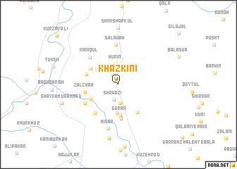
Khaz Kinī (As Sulaymānīyah, Iraq)Khaz Kinī is a town in the As Sulaymānīyah region of Iraq. An overview map of the region around Khaz Kinī is displayed below.
regional and 3d topo map of Khaz Kinī, Iraq ::
Khaz Kinī airports ::
The nearest airport is SDG - Sanandaj, located 123.9 km east of Khaz Kinī.
Other airports nearby include KSH - Bakhtaran Shahid Ashrafi Esfahani (146.5 km south east), Nearby towns ::
Kamtarān (1.7km north west) //
Shāwāzī (2.5km south) //
Shāhbāzī (3.0km south) //
Hūrīn (3.3km north) //
‘Alī Ya‘qūb (3.8km north west) //
Bāgh Nār‘īyān (4.5km south) //
Qal‘at Ganshik (4.9km south) //
Gurān (4.9km south) //
Tappah Şūfī (4.3km south west) //
Qasrān (4.4km north west) //
Darband (5.0km south east) //
Dār-ī Imām (4.5km west) //
Zalchah (4.5km west) //
Belūlah (5.4km south) //
Kānī Kirmānj (5.5km south west) //
Tappah Qalandarī (5.2km south west) //
Kānī Qūl (5.7km north west) //
Salāwah (6.4km north) //
Ḩişār (7.1km south) //
Ḩājjī Ḩasan (8.6km south) //
[all distances 'as the bird flies' and approximate]  Places with similar names to Khaz Kinī, Iraq ::
// Khosekino (RU)
// Gohouo Zagna (CI)
Disclaimer :: Information on this page comes without warranty of any kind |
||
|
Where is Khaz Kinī? Elevation and coordinates ::
Latitude (lat): 34°54'37"N Longitude (lon): 45°42'50"E
Elevation (approx.): 578m (map arrows pan, magnifying glasses zoom) |
||
|
Visiting Khaz Kinī? Hotel/Accommodation ::
Book a hotel in Khaz Kinī Travel Guide ::
Buy a travel guide for Iraq rental cars ::
car rental offers GPS waypoint ::
download a GPX waypoint (PoI) of Khaz Kinī for your GPS receiver
|
||