|
search place name
|
||
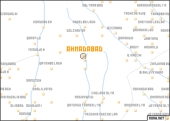
Aḩmadābād (Ostān-e Āz̄arbāyjān-e Sharqī, Iran)Aḩmadābād is a town in the Ostān-e Āz̄arbāyjān-e Sharqī region of Iran. An overview map of the region around Aḩmadābād is displayed below.
regional and 3d topo map of Aḩmadābād, Iran ::
Aḩmadābād airports ::
The nearest airport is TBZ - Tabriz Intl, located 79.9 km north of Aḩmadābād.
Nearby towns ::
Bayānlūjeh (0.0km north) //
Ālmāchavān (1.9km south) //
Gol Chavān (5.8km north) //
Tāzeh Kand-e Kohlān (4.8km north west) //
Īshmaq (6.3km north east) //
Kohel Bolāgh (7.4km north) //
Qayeh Bolāgh (6.2km west) //
Davah Bīnī (7.1km north west) //
Bātmānqelīch-e Soflá (8.0km north) //
‘Azīzābād (8.1km north east) //
Chelān-e ‘Olyā (8.9km south) //
[all distances 'as the bird flies' and approximate] 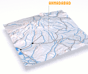 Places with similar names to Aḩmadābād, Iran ::
Disclaimer :: Information on this page comes without warranty of any kind |
||
|
Where is Aḩmadābād? Elevation and coordinates ::
Latitude (lat): 37°27'0"N Longitude (lon): 46°31'0"E
Elevation (approx.): 1924m (map arrows pan, magnifying glasses zoom) |
||
|
Visiting Aḩmadābād? Hotel/Accommodation ::
Book a hotel in Aḩmadābād Travel Guide ::
Buy a travel guide for Iran rental cars ::
car rental offers GPS waypoint ::
download a GPX waypoint (PoI) of Aḩmadābād for your GPS receiver
|
||