|
search place name
|
||
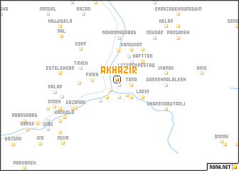
Ākhāzīr (Māzandarān, Iran)Ākhāzīr is a town in the Māzandarān region of Iran. An overview map of the region around Ākhāzīr is displayed below.
regional and 3d topo map of Ākhāzīr, Iran ::
Ākhāzīr airports ::
The nearest airport is THR - Teheran Mehrabad Intl, located 91.7 km west of Ākhāzīr.
Other airports nearby include RZR - Ramsar (180.1 km north west), Nearby towns ::
Kal Pāshā-ye Soflá (0.0km north) //
Vānā (1.3km south west) //
Kal Pāshā-ye ‘Olyā (1.9km south) //
Tarā (1.5km east) //
Nahar (1.5km east) //
Dīnān (1.9km south east) //
Shāhān Dasht (2.4km south west) //
Shamsābād (2.4km south east) //
Hāreh (2.4km south east) //
Pardameh-ye Amīrī (2.4km south east) //
Nahrestān-e Olvat (2.4km north east) //
Lūţ-e Bahrestāq (3.1km north east) //
Shangoldeh (3.4km south west) //
Lārīn (3.5km south east) //
Qalabon (4.0km north east) //
Fīreh (3.6km west) //
Bolqalam (4.6km north) //
Haft Tan (4.8km north east) //
Bāyjān (5.5km north) //
Kandīvān (5.8km north) //
Āb Garm-e-Lārījān (5.1km west) //
Tinīeh (5.6km north west) //
Bū ol Qalam (6.3km north east) //
Moḩammadābād (7.4km north) //
Darreh Palālesh (6.0km east) //
Vīārak (6.3km east) //
Gazanak (6.6km south west) //
Korf (7.5km north west) //
Garmābdar (7.1km south west) //
[all distances 'as the bird flies' and approximate]  Places with similar names to Ākhāzīr, Iran ::
Disclaimer :: Information on this page comes without warranty of any kind |
||
|
Where is Ākhāzīr? Elevation and coordinates ::
Latitude (lat): 35°56'0"N Longitude (lon): 52°17'0"E
Elevation (approx.): 1895m (map arrows pan, magnifying glasses zoom) |
||
|
Visiting Ākhāzīr? Hotel/Accommodation ::
Book a hotel in Ākhāzīr Travel Guide ::
Buy a travel guide for Iran rental cars ::
car rental offers GPS waypoint ::
download a GPX waypoint (PoI) of Ākhāzīr for your GPS receiver
|
||